Super Bowl Sunday found us in Mathias WV, about 13 miles south of Baker WV, doing our third hike of 2017, a 12-miler that we have had in the plans for some time now. After packing up and getting some coffee in our bellies, we left the house at about 8:30 Sunday morning and arrived at Lost River State Park around 10am. It's an easy drive down the interstate to Strasburg, across Little and Great North Mountains to Wardensville WV, out Corridor H to Baker, and then a quick drive south along the Lost River to the park.
 |
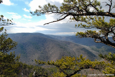
| At Miller's Rock, Lost City WV Behind Us |
A couple of miles into the park, we came to the Howard's Lick trailhead on the right, situated directly on the banks of a mountain creek. Howard's Lick Trail follows Howard's Lick Run westward upstream after having crossed the creek on a brand new suspension bridge. The trail was frozen and the creek was icing over in some of the stiller parts, yet it seemed like a nice day, starting just below freezing and theoretically heading to about 50 degrees, though I don't think it really got above the low 40s up where we were.
 |
| All Trails are Well Sign-Posted |
 |
| Crossing Howard's Lick Run on New Suspension Bridge |
 |
| The Bouncy Suspension Bridge is Neat |
While I was busy photographing the icy water tumbling gently over the rocks, Ann was already checking out potential places to cool off in the creek when we hike this again in the summer. It didn't take us very long to conclude that this is a hike that we will do again, so beautiful is the area. It's kind of fun imagining hanging out on the rocks cooling off after a long dusty hike. The creek bottom is really beautiful and peaceful with lots of smooth rock, rhododendrons, hemlocks, and white pines.
 |
| Annie Checking out Things for the Summer |
 |
| Howard's Lick Run Had a Lot of Ice in the Morning |
 |
| American Wintergreen by the Creek |
After following the creek for three tenths of a mile, we came to a stone bridge where a service/fire road crosses the creek and starts climbing up the mountain. Up this steep section of dirt road we headed, past the Big Ridge trailhead and on up and around the corner to where the orange-blazed White Oak Trail took off up and right from the dirt road, which itself climbs up to the top and we would meet again later.
 |
| Great Blazes on All Trails |
About halfway up to the top of Big Ridge, we came upon this timber-framed shelter atop a smaller ridge. It made for a nice stop to admire the view, catch a breather, and snack a little before climbing to the top.
 |
| Shelter on White Oak Trail |
 |
| Same Shelter from Above on Big Ridge |
From the photo above, you can see how far we had yet to climb to get to the top. In the photo below, I tried to capture some of the joinery in the timber-framed shelter. This is where one of the twin gussets supporting the roof is let into the roof beams and secured with double pegs.
 |
| Peg and Notch Timber Frame Detail |
It was already cold and very windy when we started out. By the time we climbed to the exposed western side of the ridgeline in the photo below, the wind was screaming at a constant 30 miles an hour with gusts up into the 40s. You can see that Annie is all hooded up. In spite of the bright sun, it was cold up on this part of the ridge and we could only face into the wind looking at the glorious views for little bits of time before having to turn around and warm up again.
 |
| After Climbing to Big Ridge |
Just a few yards from where the orange-blazed White Oak Trail dead ends into the yellow-blazed Miller's Rock Trail sits this stone shelter known as Cranny Crow. As I was shooting this photo, in fact, a crow launched into the stiff breeze just on Annie's right, out of the frame.
 |
| Cranny Crow Overlook |
 |
| Inside the Shelter |
 |
| Cranny Crow Boot Shot |
 |
| Boot Shot in Action |
 |
| The Selfie Queen |
 |
| Gorgeous Backdrop for a Pose |
Pictures can in no way do the view from Cranny Crow justice. Although you can get something of an idea from the panorama below, you can't feel the wind ripping in your face and you can't hear the silence of being alone. And certainly, the photo cannot convey the depth and texture of the scene, nor the brilliance of the sunshine. I could have stayed here all day long if the wind had not been so terribly fierce.
We did stay long enough to sign the book in the shelter, take a ton of photos, and in the lee of the shelter, snack a little trail mix that to Annie's dismay was devoid of Peanut M&Ms. It's not my fault that she cherry-picked all the little candies out of the mix on earlier hikes. While we were eating, she asked me what we were having for lunch and I told her bread, goat cheese, and chorizo with a surprise for dessert. "Peanut M&Ms!?!?" she exclaimed quite hopefully. I asked her what the odds were of me bringing candy for dessert and she said, "Slim and none and Slim left town."
We departed the shelter heading south along the southern tip of Big Ridge to make a loop around it and head back to the northern end to visit Miller's Rock.
 |
| Panorama at Cranny Crow |
 |
| Cranny Crow Shelter |
 |
| Looking South from Big Ridge |
 |
| Pine Trees Growing in Rock |
Having turned back north along the eastern/lee side of the hill, we suddenly got warm in the full sunshine without any wind as we walked along the Virginia View Trail looking out over Great North Mountain and Virginia beyond. Although we wanted to strip a layer, we didn't. We figured that it would soon be cool enough once we climbed back up to the ridgeline. As we made the short climb to the top, we emerged from the woods into a large 5- or more acre meadow containing a picnic area and a large wooden picnic pavilion. Sure enough, we needed the extra layer on the exposed ridgetop meadow and we would need another layer before the afternoon was done.
 |
| Picnic Shelter on Big Ridge |
After wandering around the meadow for a couple minutes, we left it headed west into the woods where we picked up the yellow diamond-blazed trail to Miller's Rock. The initial walk was gently uphill to the 3200-foot site of the abandoned Big Ridge fire tower. I'm sure the views 80 feet above the ground must be spectacular.
 |
| Big Ridge Fire Tower, Abandoned |
 |
| We Stopped Here for Lunch |
Right next to the tower is a cabin, no doubt for the fire wardens when the tower was in use. We decided to eat lunch here. I looked in vain for a back porch on the lee side of the cabin. Because we were fairly sheltered in the woods, the wind, while breezy, wasn't too uncomfortable to sit on the front porch and have our lunch of chorizo, goat cheese, and bread. We did both put on wind layers over our hoodies at this point and would keep them on for the remainder of the trip. It was definitely cooler in the afternoon than in the morning.
 |
| We Ate Lunch on the Front Porch of Fire Warden's Cabin |
 |
| The Survey Marker Ann is Looking at in Photo Above |
 |
| Bread, Goat Cheese, Chorizo, and a Surprise |
When I told Ann about bringing dessert for lunch earlier at Cranny Crow, she asked if I had brought Peanut M&Ms and then decided that there was no way that I would do that. So I had the last laugh when after we ate our lunch, I hauled out a small bit of Peanut M&Ms! We ate a few and put the rest into her bag of trail mix. Although hiking makes us very hungry, I'm finding that we don't eat as much at a single sitting as we would if we were not hiking. At home on a Sunday, we would have killed the lunch you see above and probably have gone looking for more. We only ate half of it during our lunch stop. Of course, there is nothing like that bogged down feeling of having eaten too much lunch to put a damper on an afternoon's hike.
 |
| Double Fisting Lunch! |
From the high ground at the fire tower, it was 2 maybe 2.5 miles gently descending to the northern end of the ridge and Miller's Rock, a decent hour's walk. The walk itself is nothing special, just a more or less straight line along a wooded ridge that is 50 to 100 yards wide, another walk through the woods. But the views at Miller's Rock are really worth the walk. You can see the towns of Lost City and Lost River in the valley below, situated on the Lost River, and you can see well into Virginia behind them.
 |
| Lost City WV, Virginia Beyond |
 |
| Great Spot for a Boot Shot |
 |
| Look at the Ripples in the Landscape |
 |
| Main Overlook at Miller's Rock |
 |
| Sandstone at Miller's Rock |
 |
| Water, Even at 3000 Feet |
 |
| Lots of Glowing Green Moss Everywhere |
The afternoon was pushing on when we arrived at Miller's Rock and we had another good 2 hours to walk back to the car, if we hustled, so we didn't stay long admiring the view before doing a 180 and heading back south along Big Ridge. Once back south of the fire tower, the path forked. We had come from the right, so we chose to go back via the left which brought us to the north end of the meadow that we had visited earlier and by a cabin that we had glimpsed in the distance earlier in the day, a cabin attributed to a William Tusing in 1840. Think about this. When he built this cabin, he was a Virginia resident, a resident of Hardy County, VA. The western counties of Virginia would not form their own state until the Civil War, some 25 years later.
 |
| 1840 William Tusing Cabin |
We re-crossed the meadow and retracing the same trail we approached on, started to descend the hill towards the start of the Virginia View Trail that we had hiked earlier. Here, we opted to go straight down the hill on the Big Ridge trail, whose trailhead we passed early in the morning when climbing up the service road. Parts of the trail were steep and parts were rocky. The sun was going fast as we were on the east side of the ridge and we came upon an area where scores and scores of icicles were hanging off the cliff faces, though it was not light enough to photograph them.
The trip down was hell on my knees but fairly interesting going from oak and beech forest at the top, down through mixed trees, and through a really neat belt of pines undergrown with mountain laurel, the trail softly padded in pine needles. About this time, we rounded the southern end of the trail and were greeted by the sun again, very low to the horizon and necessitating pulling my ball cap low over my eyes.
The final stretch of the Big Ridge Trail was a typical dry creek bed ravine between two hills replete with lots of small, loose, foot-irritating rocks. As we descended, mixed flocks of birds (titmice, juncos, nuthatches, creepers, chickadees, wrens, and Yellow-Rumped Warblers) kept us company. A Hairy Woodpecker flew right up to my feet and started pecking in the soil; I've never seen one on the ground before, that being the usual province of the flickers.
Back down the service road and back along Howard's Lick Run to the car we went. At the bottom, I stopped on the stone bridge to photograph the creek flowing away from me and I happened to spy Annie stretched out on a log a tenth of a mile from me. You can see her raspberry rain jacket in the photo if you look closely. She was very far ahead of me because my knees will not let me get down a hill very fast. I can crush a climb, but the descents are quite painful. Even Annie's knees were hurting after the steep almost 2-mile descent, hence her resting on the log waiting for my slow ass to catch up.
 |
| Annie Crashed on a Log |
We were a little concerned it being Super Bowl Sunday that Lost River Brewing in Wardensville, our habitual post-hike stop in these parts, would be jammed to the point where we wouldn't be able to get a seat. I started to question this when we pulled into the parking lot to find it empty. Save for another couple from DC in the bar, we were the only others. Service and the kitchen were in slo mo as well, slow even by Lost River's slow standard. When the bar tender finally arrived at the bar (how long do you have to wait for a beer at an empty bar?) she told us that they are normally dead for the Super Bowl. Who knew? We both crushed hamburgers before making the trip back over the mountain to Winchester.
 |
| Post Hike Black Ale at Lost River Brewing |
 |
| My, Doesn't This Look Good! |


What a great blog! What's the best way to follow you? I don't see any "follow" links.
ReplyDeleteHmm... There used to be follow links. Looks like Blogger changed the template. Anyway, there are now subscription and follow links in the sidebar at the top of the page. Glad you are enjoying our endeavors.
ReplyDelete