Given the popularity of Smith Rock State Park, parking can be quite the issue. Fortunately, we arrived before 9am on a weekday and were able to get one of the last spots near the trail down into the river canyon. Cars were circling like vultures hunting for people departing when we arrived back at the car in the early afternoon.
 |
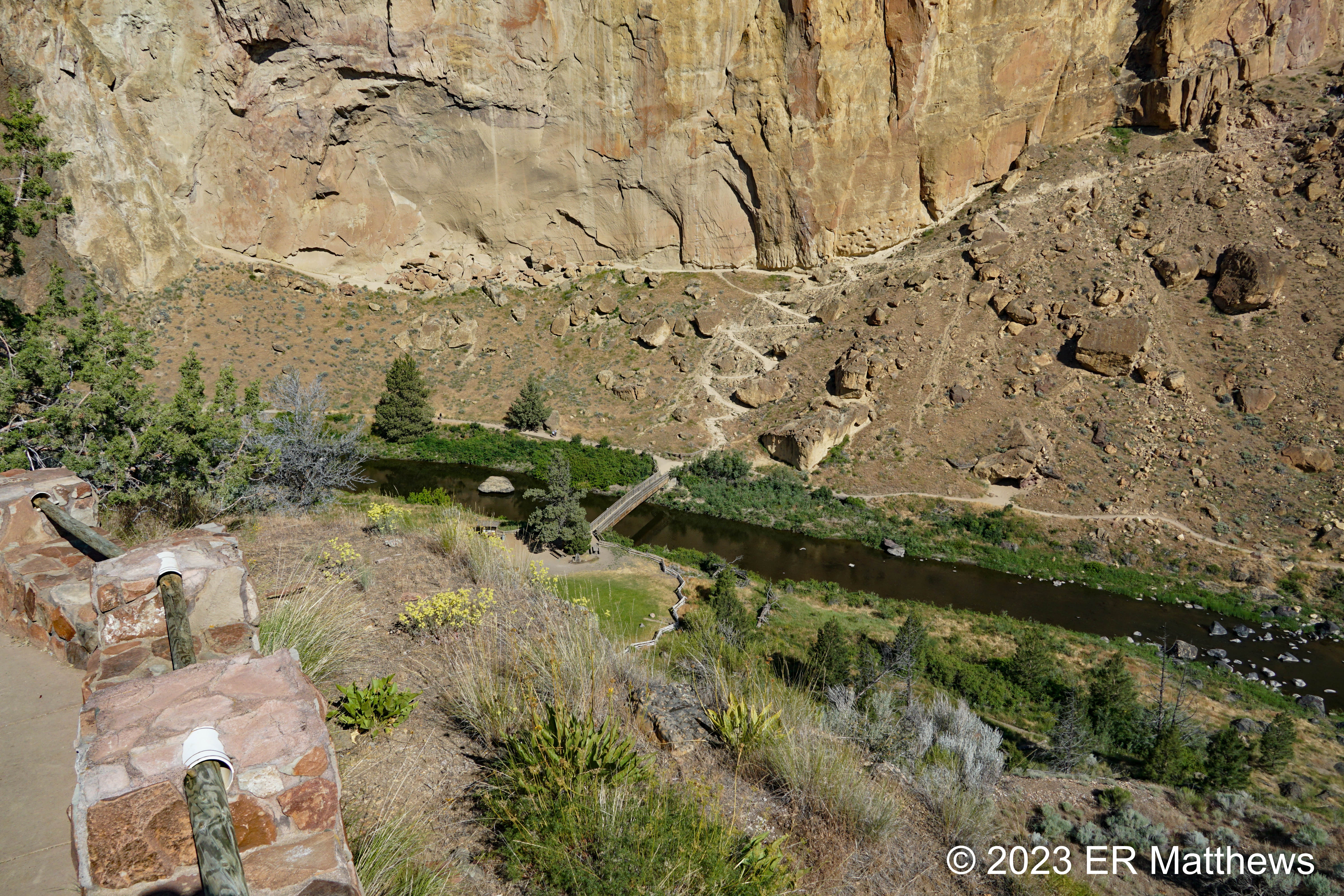
Start of the Misery Ridge Trail
Switchbacks Bottom Right of Photo |
 |
| Switchbacks from the Bridge Leading up to Misery Ridge |
In the photo above, taken a bit below the parking lot, you can see the Crooked River below and the footbridge leading across. Come July 3, the existing bridge will be demolished and a new one will be built, taking many weeks out of the summer schedule. It will not be possible to cross the river to the main spires and rock climbing areas unless you are willing to wade the river at the horse ford about a quarter mile downstream. In large part, this is what spurred the timing of our visit this year, along with the fact that the climb up Misery Ridge is totally exposed and brutally hot as the summer moves along.
 |
| Western Fence Lizard, Surprisingly, on a Fence |
By contrast with our visit at the same time last year during which a lot of spring flowers were in bloom and despite our very delayed spring this year, most of the flowers on the south and east side of the park were bloomed out. None of the ubiquitous Balsamroots, for example, were still in bloom and surprisingly, our usual fall bloomer, Rabbitbrush, was blooming sporadically in the scrub on the southwest side of the river bottom.
 |
| Unusually Early Blooming Rabbitbrush, Ericameria nauseosa |
 |
| Tall Tumblemustard, Sisymbrium altissimum |
As we started to climb up the Misery Ridge trail and moved to the northwest towards the Red Wall, we left the relatively lush flora of the river bottom behind. The loose scree slopes at the bottom of the cliffs were covered in large stands of White Horehound, a mint that thrives in tough hardscrabble places. Although I have heard of horehound candy, I can't really imagine it. The leaves smell quite musty and unpalatable to me, unlike the vast majority of its mint cousins.
 |
| White Horehound, Marrubium vulgare |
 |
Ultra-tiny (4-5mm) Blooms of Perhaps
Common Fiddleneck, Amsinckia menziesii |
I don't mind owning up to having some difficulty with this climb this year. In years past, I could have marched right to the top without stopping, but my stint on the sofa with a broken foot has really set my fitness back a long way this year. I'm really going to have to work hard this summer to regain my Mountain Goat status. Ann and I took advantage of nearly every stopping point along the trail to suck in oxygen, the rock outcropping below included.
 |
| Perhaps a Third of the Way to the Top |
As we worked our way along the base of the sheer cliffs to the Red Wall (whose color you can see in the photo below), we were constantly strafed by chatty swallows of the Violet-Green persuasion especially down near the river whose water these most common western swallows patrol on the regular. Higher up, I happened to glance up to see tons of swallows going to and from nests under overhangs on the cliff wall. Knowing Violet-Green Swallows to be cavity nesters and there being no real cavities on the sheer cliffs, I snapped a photo of these swallows.. Although I could not tell from the naked eye, once I enlarged the photos, I could see that these are indeed Cliff Swallows with their impressive nests made of balls of mud, scavenged from the river banks below.
 |
| Cliff Swallows Nesting |
Flora was scarce on the parched hillside, especially anything in bloom. But starting about 500 feet above the river and about 100 feet below the top, I started to see largish rafts of a new plant to me with faint blue five-petalled blossoms. I most often think of phacelias as plants of the cooler forests, so these Branching Phacelia plants struck me as out of place.
 |
| Branching Phacelia, Phacelia ramosissima |
There is a decent overhang just feet below the top that provides welcome shade against the cool rocks. I would be lying if I said I did not lean against that cold rock and suck oxygen to counter the lightheadedness and visible black spots of hypoxemia. My chest and lungs were burning, Misery Ridge living up to its name on this day. Ultimately, we climbed the last few feet up to the top, where I sat in the shade of my favorite Western Juniper, whose lower limbs have been rubbed smooth and shiny by thousands of hikers.
 |
| Welcome Shade Atop Misery Ridge |
One of the unfortunate but inevitable consequences of my broken foot is a loss of muscle strength in my ankles and calves and hence a loss of balance. That coupled with the lightheadedness from the climb (along with my awful fear of heights) kept me from the higher and more exposed points on the cliff where Ann ventured with nary a care.
 |
| Expand This Photo to See How Ann Feels About the Climb |
 |
| The Pinnacles Behind a Hopsage |
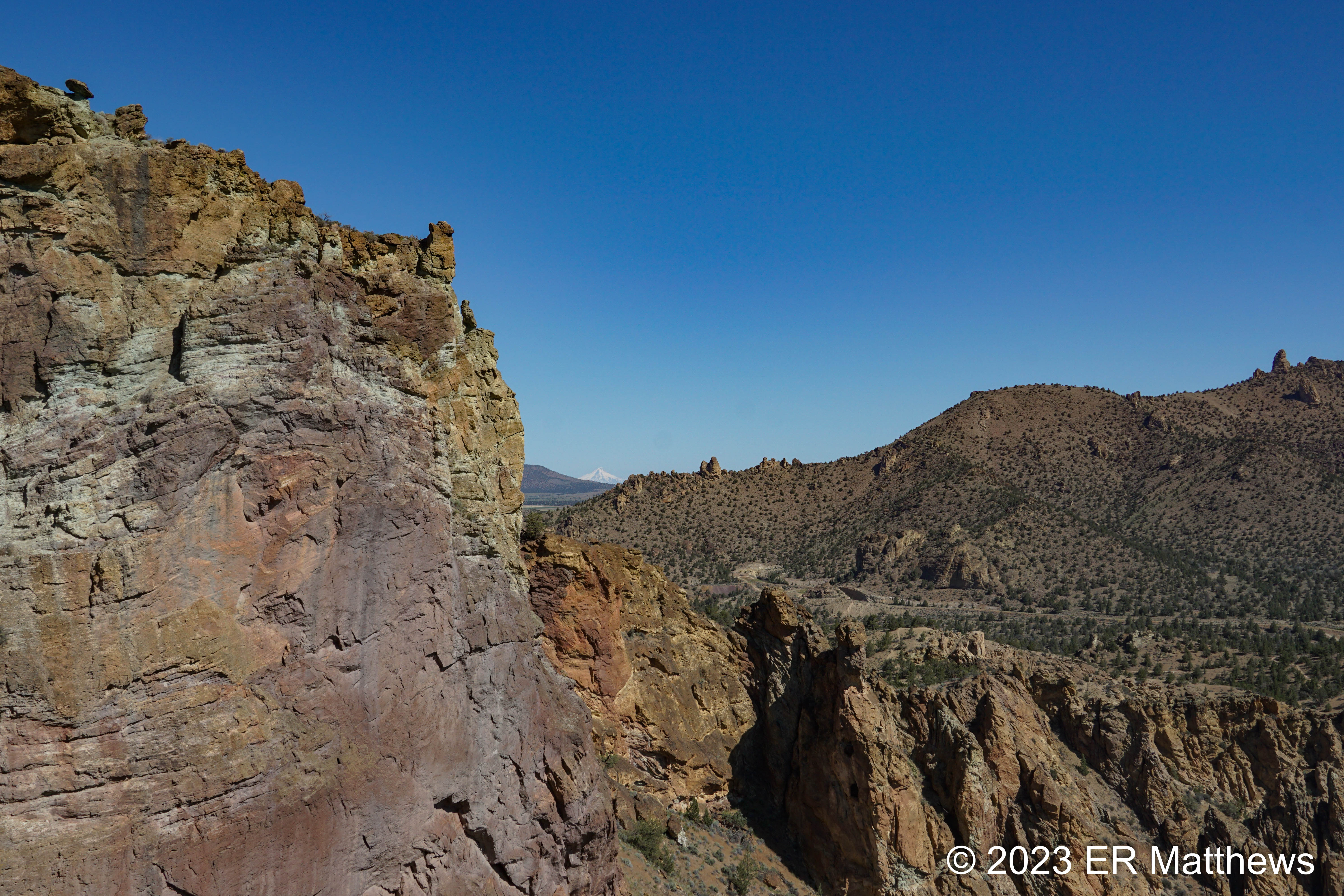
Up on top of Misery Ridge, some 600 feet above the river, it is a little cooler and so some of the flowers that had bloomed out below are still in bloom, including some Spiny Hopsage bushes with their thorns and beautiful pink blooms. Some appear to have cream colored blooms as well. This plant sits in front of the climbing area known as the Pinnacles. In the upper right of the photo, you can just make out Mt. Bachelor and Broken Top to the south and west of Bend.
 |
| Spiny Hopsage, Grayia spinosa |
The back (north) side of Misery Ridge affords great views of Black Butte, Mt. Washington, Three-Fingered Jack, Mt. Jefferson, and in the distance, Mt. Hood. There is also a funny looking and appropriately named spire on this side called Monkey Face, a favorite with climbers. As we made our way past Monkey Face and then started our descent to its foot, we watched a pair of climbers leave the relative safety of the monkey's left eye and start the climb to the top.
 |
| Mt. Hood, 75 Miles Distant, from Backside of Misery Ridge |
 |
| By Monkey Face, Crooked River Heading North of the Park |
 |
| Monkey Face from the Side |
 |
| Climber Leaving the Monkey's Left Eye |
As we started our descent on the very steep trail beside Monkey Face toward the river, we were immediately serenaded by a bunch of Rock Wrens, a common sight in this area. We watched many of the tiny grayish birds flit about the rocks as we walked down the trail. One even serenaded us from the top of a juniper.
 |
| Pair of Rock Wrens |
As we descended towards the river on the back (northern) side of Smith Rock, we saw a few clumps of the typical ray flowers that we would expect to see in bloom at this time of year, thanks to the more shaded aspect of that area.
 |
| Woolly Groundsel, Packera cana, with a Yellow Crab Spider |
 |
| An Unidentified Purple Aster or Erigeron |
Once we got down the trail to the base of Monkey Face, we continued north on the Mesa Verde trail to the intersection with the River Trail. Along the river, we made our way left slowly back to the car through the very different looking riparian zone, far, far different from the upland desert we had been walking through. On our visit a year ago, we spent the vast majority of our walk traversing the arid badlands around Smith Rock, so walking the river felt like a very different park. We saw the vast majority of wildflowers in this wetter and in places thanks to some riverside trees, more shaded, area.
In this same area, we saw small mock oranges, to about two meters high, in full, fragrant bloom. These plants owe their scientific name also to Meriwether Lewis who collected samples and returned them to the East Coast, though they had been used for ages by the native tribes for arrow stock and other uses. The local clematis vines were using these shrubs as natural trellises. I am used to the local clematis on the East Coast being fall blooming, so these struck me as blooming at the wrong time of the year. Nevertheless, the combination of two very fragrant blossoms perfumed the air around the trail in a delightful manner.
 |
| Western Clematis, Clematis ligusticifolia |
 |
| Lewis's Mock Orange, Philadelphus lewisii |
The creek bottom (I say creek, but this is technically the Crooked River) is full of Poison Hemlock, at places hemming the trail in on both sides. I do not know it to be a physical irritant
à la poison oak, but it contains alkaloids that are toxic upon ingestion to most animals including humans. Best to give it a wide berth.
 |
| Poison Hemlock, Conium maculatum |
 |
| A Massive Ponderosa Creekside, Pinus ponderosa |
 |
| Big Stands of Leafy Spurge, Euphorbia esula |
 |
| Beautiful, but Invasive, Yellow Iris, Iris pseudacorus |
 |
| Cutleaf Beardtongue, Penstemon richardsonii |
 |
| Blue Mountain Prairie-clover, Dalea ornata |
On the way up to the top of Smith Rock, I noticed several small lilac five-petalled blooms on some very thin foliage, blooms that reminded me of
Claytonia a bit. On the scorching hot cliff face, the plants had almost no foliage, consisting mainly of wire-like stems, and each plant might have a bloom or perhaps two. Contrast that with the patch just below from the shady side of the hill, growing at the foot of a Ponderosa Pine with lush green stems and dozens of blooms.
 |
| Narrow-leaved Wire-lettuce, Stephanomeria tenuifolia, from Shady Side |
 |
| Stephanomeria Bloom From Sunny Side |
I have a pretty good ear for bird calls, at least back East where I heard them all my life, out West now for six years, not as much, but I like to think that I can get at least pretty close. But I got fooled. While walking along the river, I heard what I really thought was an Osprey. The bird was too far away and too backlit for me to see, but when I took a picture of it and enlarged the photo, I knew I had been had. The Bald Eagle below was making sounds that were eerily similar to an Osprey.
 |
| Bald Eagle in a Ponderosa |
 |
| It's Gosling Season |
The whole point of walking back to the car along the river was to hopefully see one of the river otters that others told me I might see there. We had moved into an area of the river that was less whitewater and more sedate when Ann, ahead of me on the trail, yelled "Otter!" This was her first time ever seeing one in the wild and I'm happy she got the opportunity. I watched it dive lazily in the water and surface, time and again, to roll on its back and eat the fish that it had just caught.
Nearing the footbridge back to the car, we passed an area of striking vertical rock called the Dihedrals. I snapped a picture because I find this formation fascinating. It was not until I got home and unloaded the photo on the computer that I could see a climber on the vertical face in the shadows just to the left of the tree. People climb some crazy stuff!
 |
| Part of the Dihedrals |
 |
| Calm Water Where the Otter Was Hunting |
Just before we reached the footbridge to make the excruciatingly steep climb out of the canyon back to the car, I spied a milkweed just coming into bloom, a milkweed species that I do not know. I know a half dozen or more species back east, but have no experience with milkweeds out west. This was a patch of a western species called Showy Milkweed.
 |
| Showy Milkweed, Asclepias speciosa |
After struggling up the steep climb out of the canyon, the sight of our car was so welcome as was the thought of a beer to celebrate. We stopped in Redmond for a beer, but it turns out that we were really too overheated from the hot walk to drink beer.
Hot or not, I'm glad that we were able to fit in a hike of Misery Ridge in the relative cool of June and before they rip out the bridge for the summer. It was fun to go back to a place we have been before and have a totally different experience. Also, otters!


No comments:
Post a Comment