It's been about three weeks since the ice melted on the Deschutes River Trail and I've been taking advantage of that to walk through the canyon about five times a week. Today, Ann had a morning off from her workout class and agreed to walk with me. I wanted to walk some place other than along the river. That's a walk that I love, but fifteen times in the last three weeks is plenty.
Because Ann hasn't been doing much if any walking this winter, I wanted to pick a short walk that was more or less flat. And because it's just early April, going west of town is not in play; the snow will not clear until the end of June/first of July.
I chose the Oregon Badlands Wilderness just east of town because it is close and because opportunities to hike in the badlands in reasonable temperatures are coming to a close. The Oregon Badlands are a place best hiked from fall to spring, through the winter when it is largely free of snow. Now, after the winter wet season, the sand is still relatively compacted and easier to walk on than it will be after it dries out and gets chopped up by a lot of foot traffic.
 |
| Loop Hike at Reynolds Pond Trailhead |
Ann had hoped to see some wildflowers, but it's just too early here in Central Oregon. We saw none. Still, it was a beautiful day with blue skies, minimal clouds, and temperatures in the low- to mid-60s, a nearly perfect day.
There are many ways to get into the 29,000-acre (45-square mile) BLM-managed wilderness area and in the past, we have gone in on the southern edge bordering US 20, the highway out of Bend. I selected a trailhead on the opposite side, the north side just south of the town of Alfalfa, the Reynolds Pond trailhead. I selected it, I suppose, because we hadn't been there before and if I'm honest, I was curious about a pond in the middle of the desert.
Because I have not traveled these roads, I relied on Apple Maps to route us to the trailhead, a mistake as it turns out. It had us driving onto somebody's ranch where we turned the truck around at the bunkhouse. Google Maps got us from the main road to the trailhead with little issue once we departed the ranch.
From the Reynolds Pond Trailhead, we had route options for a 5-mile circuit hike, a 6-mile out-and-back, and any number of treks longer than 10 miles. I tentatively planned for a 6-mile circuit, but we ended up short-circuiting this for a 5-mile walk, thanks to no water yet in the irrigation canal letting us cross it at any location we desired, rather than on a bridge. Water will start flowing for the season at the end of this week.
Our route took us in a loop from Reynolds Pond along the Nighthawk Trail to the Tumulus Trail to the Carey Act maintenance road along the canal back to the pond.
 |
| At Trailhead, Crossing the Now-Dry Central Oregon Canal |
 |
| Reynolds Pond |
We circled the south side of the pond (trails go both ways), a muddy 12-acre bit of water in an ultra-dry area. Although I expected to see more birdlife around the pond, the only waterfowl were a couple hundred Canada Geese who have staked out nest sites on one of the many tiny islets in the pond. We saw several battles as the honkers squabbled over turf. The willows around the pond were crawling with tiny birds, mainly Ruby-Crowned Kinglets.
 |
| Canada Geese Nesting on an Islet |
 |
| Willows Starting to Green |
 |
| East Side of Pond: Snow-Capped Cascades |
On the far side of the pond, we headed out into the scrub on the Nighthawk Trail. In going out into the Badlands, the primary attraction is the interplay of the Western Juniper trees with the Big Sagebrush and the ubiquitous lava rock formations. If you're looking for traditionally beautiful landscapes, you may have to rethink your expectations of the desert whose beauty lies in its harshness. The sites to see are the twisted forms of the trees and the tortured landscape born of fiery lava. There are few long vistas here in the desert; most scenes are quite intimate.


At one point on our ramble along the Nighthawk Trail, Ann spied a cleft in a lava formation and up she went. One of the best things about the Badlands is going off trail and climbing through the the lava. This particular formation is a pressure ridge, called a tumulus by volcanologists, that stands 30-40 feet above the sand. It is split down the middle with both sides of the split sloping down at about 35 degrees away from the split. An ersatz trail runs through the middle of the cleft, if you don't mind twisting through the sagebrush.
 |
| Climbing up into a Tumulus |
 |
| Navigating the Tumulus |
Meandering through the cleft in the tumulus meant we had to push our way at times through the sagebrush. I love the smell that the leaves give off as you brush through them. Others detest the smell. This time of year when bushwhacking, you need to keep your head on a swivel looking for rattlesnakes. The early spring and the late fall are the seasons in which they sun themselves on south-facing rock slopes just after emerging from or just before going into their burrows. We encountered no snakes.
I am always amazed at how sagebrush thrives in inhospitable climates such as this. And I am even more impressed that it can grow in even the tiniest cracks in the lava. It's a pretty amazing plant.
 |
| Big Sagebrush (Artemisia tridentata) Growing in a Lava Crack |
 |
| Baby Sagebrush in Lava Crack |
 |
| Still Life with Very Old Sagebrush Trunks |
 |
| Last Fall's Bloom Spikes, Now Dessicated |
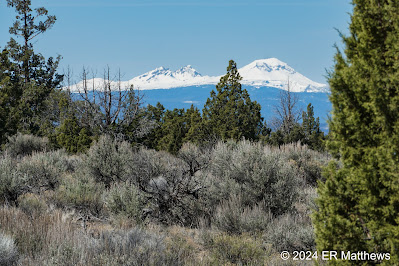
From the top of the tumulus that we followed for about a quarter of a mile, we had the best views of the day, being elevated somewhat off the desert floor. To the south we got great views of Horse Ridge and to the west, the Cascade Peaks. At one point, we had all the snow-covered local Cascade peaks in view: Bachelor, Tumalo, Broken Top, South Sister, Middle Sister, North Sister, Washington, Black Butte, Three-Fingered Jack, and Jefferson. It was quite a spectacularly clear day and had we been up at elevation, there is no doubt that we could have seen the peaks in Washington State.
 |
Three Sisters: South, Middle, and North
|
 |
| Bachelor Framed by Juniper Trunk |
 |
| Broken Top and South Sister |
I would be remiss if I did not mention that it is terribly easy to get off your intended route in the wilderness area. You cannot really get lost with Dry Creek to the east, Highway 20 to the south, and the Central Oregon Irrigation Canal to the west and north, but you can surely end up in seemingly the middle of nowhere if you are not careful. It might be a long, dry hike back to civilization, but it might also be very uncomfortable.
 |
| Shout Out to the Trail Maintainers |
The last time we were there, we got off course despite paying careful attention to our route. With the actual track being very faint in places and myriad intersecting game trails in others, you can get yourself misplaced, especially if you are prone to bushwhacking to see the amazing lava formations, as we are. Having learned from our previous experience, I used GPS to keep tabs on our location. I highly recommend that.
This time, we did bushwhack a bit, but never got too far remote from the trail. I have to commend the trail maintainers who this winter clearly put a lot of effort into marking the Nighthawk Trail with cairns and signposts. And in places where it was easy to go wrong, they have blocked the wrong way with brush piles. Thank you, thank you, thank you!
Western Juniper (Juniperus occidentalis) is the key tree of the Oregon Badlands Wilderness. It is probably the signature species of central and eastern Oregon, the only place where it grows save for a few pockets in surrounding states. It is also a species of some controversy. While the forms of ancient trees—many in the Badlands are 1000-plus years of age—are amazing to look at, it is a species that is expanding rapidly in many areas. Some call it invasive.
Historically, wild fires had kept these highly flammable trees in check, but fire suppression policies of the last century allowed the trees to go wild. They encroach on grasslands which drives ranchers nuts and they are notoriously thirsty trees, reducing stream flows and disrupting the habitat of other plants. For land managers, the Western Juniper is a paradox: part symbol of this region and part pest.
Regardless, I enjoy looking at these trees and marveling at their forms. They are of a class of junipers that have two different forms at different ages. When they are young, they have painfully spiky needles like Common Junipers (Juniperus communis). As they age, they develop flattened, scaly foliage that resembles Arborvitae or Chamaecyparis. The tree forms also vary. Young trees are narrow and tall, resembling Eastern Red Cedars (Juniperus virginiana) in form. The older trees become much more rounded and from a distance, can look like oak trees. Fascinating.
 |
| Juniper Makes Long-Lived Fence Posts |
 |
| Mature Juniper Form |
While quite a few species of animals and birds make their home in the Badlands, not too many are visible in the late morning when we were there. Of four-footed animals other than dogs, I saw mainly a few mule deer tracks and then what I believe to be Pronghorn tracks, though it is hard to say because the impressions in soft sand are not all that clear. Though groups of small cloven tracks would not belong to a herd of fawns! And this is not an island in Florida where the Key Deer are tiny!
Birds were a bit more in evidence. We were never far from a raven and we saw many, many pairs, some of which were very close to us. I am always surprised when I see these birds up close how big they are, the size of a Red-Tailed Hawk. As we moved through the trails, we heard non-stop calls from Northern Flickers, Western Meadowlarks, and Mountain Bluebirds. In the sky, I happened to see a lone Prairie Falcon and a lone Kestrel. Not a lot going on animal-wise during the middle of the day.
 |
| Raven with a Grayish-Looking Chest |
 |
| Mountain Bluebird |
From about two miles in, Ann was complaining about her feet, the one time I rolled out of the house without my first aid kit in my day pack. Sadly, I moved it to another pack in preparation for a 5-day rafting trip on the Owyhee river and I am kicking myself for rushing out of the house without it. By the time we got back to the truck, because she opted to go without socks, she had messed her feet up terribly. At one point, she took off her shoes and made the return trip barefoot.
 |
| Wounded Paws |
Her tender feet caused us to short-circuit a bit of the marked trail and cut across the irrigation canal to the maintenance road which was the shortest path back home. Although I wanted run the final mile or so to go get the truck and drive back to pick her up, the road is gated. We were able to cross the canal because they don't start diverting water from the Deschutes River for the season until April 15, letting us walk across the bare lava that forms the bottom of the canal. This also gave us the opportunity to look at some of the lava formations scrubbed bare by the water.
 |
| Central Oregon Irrigation Canal |
As I sit here on an unusual rainy day here in Central Oregon typing this, I am reflecting on our gorgeous day with blue skies out in the desert. I'm really happy to have this resource just a few miles from the house. And while I am reflecting, I have learned my lesson about never leaving without my first aid kit. And I hope Ann has learned something about taking better care of her feet.


No comments:
Post a Comment