Hike number 20 continued our further exploration of the George Washington National Forest near us along the Virginia and West Virginia border. We did a loop on Sunday that was new to us for the most part around Gerhard Shelter, although we have hiked north, south, east, and west of this loop. It was a great hike for solitude: we saw no other person all day. The last person to sign the book at the shelter signed it five days before us.
Heading into the GWNF out of Wardensville on Waite's Run Road, we parked at the bridge over Waite's Run and walked the County Line section of the Tuscarora north towards route 55, stopping for lunch at the Paul Gerhard shelter, one of the nicest and cleanest shelters I've seen on any trail. The shelter is about halfway between Waite's Run Road and Route 55, about 4 miles in. From the shelter, we looped back on the east side of the mountain back through Wilson Cove to the car.
 |
| The Start of the Hike |
Looking at the map below, the initial part of the hike, not shown in any detail on the map but where the blue-blazed Tuscarora crosses Waite's Run Road, is a short segment of blue-blazed fire road labeled County Line Trail that runs from the Waite's Run Road up the hill. In just under a mile, the blue-blazed Tuscarora leaves the fire road very obliquely off to the right, almost counterintuitively if you're looking at the map. Turn right and soon you will find yourself climbing the hill at a pretty good clip. I found this section to be a lot of fun with its steep twists and turns.
 |
| Our Loop Hike on the Tuscarora |
Beyond the switchbacks, the trail ultimately straightens out while climbing more gently to the ridgeline. Once at the shelter (at the very top of the photo), we headed east down the hill into Virginia and then back south on the unblazed fire road (FR 93) shown in gray. This road ultimately merged into the Vance's Cove Trail (on the map, the trails look disconnected but they are not) which turned slightly right onto the Wilson Cove Trail. This trail starts just as you head south into West Virginia from Virginia.
In a couple of miles, the Wilson Cove Trail goes right by Wilson Cove and empties right back into Waite's Run Road. It's maybe just shy of a mile back to the bridge over Waite's Run where we parked. The entire loop was 11 miles. The stated mileage was 10.6 miles, but PATC has relocated the Gerhard Shelter Trail so that it is no longer a straight shot down the hill, but rather a more pleasant walk with switchbacks. It is still pretty steep though.
 |
| Common Speedwell, Veronica officinalis |
In the middle of the fire road and up again on the ridgeline, I saw several patches of Common Speedwell, the first I have seen blooming this year. And as I predicted last week, the Mountain Laurel is coming into its own and we saw vast patches of it in bloom, with blooms anywhere from snow white to very pink.
 |
| Stunning Mountain Laurel, Kalmia latifolia |
 |
| A Much Pinker Mountain Laurel |
 |
| Yellow Violet, Viola pubescens |
It's only been in the last couple of weeks that we have seen fungi start to grow. I thought the following picture made an interesting still life.
 |
| Shelf Fungi Still Life |
And the flies started coming out in full force this week. We have been remarkably bug free until this week, but the flies in particular seemed to be everywhere. This is the first time we have seen millipedes on the move but they are a common sight all summer.
 |
| North American Millipede, Narceus americana |
When I was a youngster and young teenager, I went to Boy Scout camp over in Augusta County, across the Blue Ridge from my home in Albemarle County. In those damp woods, I would see hundreds of Red Efts, the juvenile form of the Eastern Newt. This land-dwelling juvenile form wanders for a couple or three years until it finds a pond and transforms into the aquatic adult form with a bladed, paddle-like tail. While the adults can grow to be sizeable, the efts that we saw were generally not much longer than two acorns put end to end. Ann had never seen one before so it was pretty neat to show her one. I saw about six or seven all day long.
 |
| Red Eft, the Juvenile Stage Eastern Newt, Notophthalmus viridescens |
Other than the blooming mountain laurels, one of the other main sources of color along the trail headed to the ridge of Great North Mountain was Snowbells, small shrubs with very sweet bell-shaped white blossoms.
 |
| Snowbells, Likely Styrax grandifolia |
 |
| Pink Lady's-slipper, Cypripedium acaule |
At one point, Ann pointed at a False Solomon's Seal and asked what it was. After I identified it for her, she asked what true Solomon's Seal looks like. There happened to be one in bloom not two feet away. In the wild, Solomon's Seal blooms are rarely like those of specimen plants grown in gardens. The green blooms suspended under the leaves are very shy and hard to spot and do not photograph well.
 |
| False Solomon's Seal, Maianthemum racemosum |
Greenbriers are very common in our woods and are a real problem for hikers who bushwhack. The thorns on these fairly aggressive vines are tenacious. But the seedlings have a certain beauty with whorls or four or five leaves. It's hard to say which greenbrier this one is, but judging from some of the adult ones nearby, I'm going with Bristly Greenbrier and not the Common Greenbrier.
 |
| A Greenbrier, Likely Bristly Greenbrier, Smilax hispida |
Any girl that is going to thru-hike the AT needs a trail name. I'm going to start with "Layer Break." I say this lovingly, but I have just never seen someone put on and take off quite so many layers of clothes in a hike as she.
 |
| Annie Gets a Trail Name: "Layer Break" |
 |
| Another Gorgeous Azalea |
 |
| The Blueberry Crop Looks Great This Year |
The uphill climb to the ridge was something on the order of three miles and we covered it in good time, stopping every now and again to listen to the cuckoos calling. We finally saw one flit up in the top of a tree, but of the many we heard, that was the only one that we saw. Except for a steep bit in the switchbacks, the trail climbed fairly gently. As we neared the ridge, we pretty much abandoned hope of any views as we had clearly climbed up into the clouds.
 |
| Nearing the Ridge, in the Clouds |
Finally, when we topped out, we could see, well, nothing. We were wading through knee-high grass for a few hundred yards in the clouds. I only found one tick on me once I got through to the other side and that seems pretty good for I figured I would be covered. So, there were no views, but the clouds were trapping something very delightful smelling that neither of us could place. We would soon discover what it was.
 |
| The Ridge Top Views Were Astounding; Not! |
Suddenly, we came upon interesting looking three-leaved low shrubs on both sides of the path and having just come through big patch of poison ivy, I was on high alert for three-leaved plants. Although most of the leaves on this one in the photo below look like poison ivy, the vast majority reminded me of poison oak from out west. I was in no hurry to touch this plant, but I took my time looking at it because I know that I have never seen such a plant before. I figured it must be a sumac, but it was beyond my knowledge. Back home, it was easy enough to determine that it is the non-poisonous Fragrant Sumac, a favorite of professional landscapers for its beautiful red foliage in the fall. Live and learn.
 |
| Fragrant Sumac, Rhus aromatica |
Just beyond the sumacs, we came upon many White Fringetrees on either side of the trail, some of them arching gracefully over the trail, slightly bowed under the weight of the clouds condensing on them. As we walked under, we figured out the source of the intoxicatingly sweet fragrance that we had been smelling for a few minutes.
 |
| Smelling the Fringetree |
 |
| Basketball-Sized Clump of White Fringetree, Chionanthus virginicus |
Keeping the fringetrees company were many, many Viburnums, some with softball-sized blossoms, some more white, some more yellow. Most were Northern Arrow-wood, perhaps my favorite of all our local species.
 |
| Northern Arrow-wood, Viburnum recognitum |
After walking across the exposed ridgeline for a few hundred yards, we started down into the woods again and were serenaded by tanagers at every turn. In just a few minutes, we came into a clearing where the Gerhard Shelter is situated.
 |
| Paul Gerhard Shelter |
We sat and ate lunch rather quickly. After walking for a couple hours to get to this point, we were both a bit sweaty and we started to chill in the cool air. I stayed behind to sign the log book in the shelter while Ann, in an effort to get warm, headed on down the trail towards the spring and the fire road beyond. I took off behind her about four minutes later and it was then that I understood why the mileage to the spring and fire road (FS 93) from HikingUpward was different from the mileage posted on the shelter: PATC has recently built a marvelous new trail that switchbacks down the very steep mountain and replaces the old trail which was a straight arrow shot down the hill.
Even though the new trail is less steep than the old, it is still pretty steep. If you are staying in the shelter, you are not going to want to walk 6/10 of a mile down this hill to the spring and then tote your water back up. You are best advised to pack it in from the nearest source.
As we were walking down to and by the spring, the flora really started changing on the east side of the mountain compared to the west. All of a sudden, Rattlesnake Weed was blooming everywhere and here and there were clumps of Long-leaved Bluets, the first I have seen this year. Several Wood Thrushes entertained us with their enchanting calls as we made our way down to the forest service road, where we emerged into light sunshine (finally!) and turned right and south along the east flank of the mountain.
The walk at this point was flat to downhill along a gravel road which ended about 3/4 of a mile along, only to continue as an un-blazed path through the woods. Soon enough, this trail would merge directly into the yellow-blazed Vance's Cove Trail. Although this sounds like a lot of landmarks to look for, it really isn't any big deal; you just keep walking straight ahead south. Alas, horses have really torn parts of this trail all to hell and there are a lot of sloppy and muddy sections.
Finally, the Vance's Cove Trail ends at another forest service road, which is labeled the Wilson Cove Trail. The road runs right along the border and as you move from north to south, you cross back into West Virginia, having been in Virginia since leaving the shelter. A right on Wilson Cove Trail will take you back to Waite's Run Road and your vehicle.
 |
| Coming South into West Virginia |
Just as soon as we popped out on the Vance's Cove Trail, a much wider road, Ann spied something red (and very hard to miss) in the trees just across the way, a Scarlet Tanager just above eye level sitting out in the clear. Tanagers usually hide at the tops of trees and are frustratingly hard to see, but easy to hear, sounding a bit like an enthusiastic House Finch. We heard many of them during the hike, as well as their cousins the Summer Tanager. I shot a few frames of a Summer Tanager, but they were all in dark profile with no detail. The bird was just too backlit.
 |
| Scarlet Tanager, Piranga olivacea, Very Common Here |
For the duration, a couple miles, of our walk, we saw a lot of fairly common roadside flowers, but one gave me pause. On the east side of the road, we saw predominantly hawkweeds, which with their multiple blooms at the top of a long stalk are fun to look at from above. On the west side, the shadier side, the hillsides were covered in Rattlesnake Weed. And then here and there, we saw one that looked very different.
 |
| Meadow Hawkweed, Hieracium caespitosum |
It has a bloom similar to many plants, and not too far off of a dandelion, which naturally were here and there all over the place, but it sported single blooms 12 to 14 inches off the ground, a single bloom on a single bloom stalk per plant. Each plant had a strong basal rosette of highly toothed leaves. This is the False Dandelion,
Hypochaeris radicata, a beautiful flower.
 |
| False Dandelion with a Bee Visitor |
So common are Ox-eye Daisies that I rarely photograph them. Yet, the one below was one of the very first of the year and too perfect a bloom to ignore.
 |
| Ox-eye Daisy, Leucanthemum vulgare |
Likewise, Black Locusts are not notable in these parts, being almost a weed and certainly among the most prolific colonizers of barren areas. What is notable is that we haven't seen any blooming in two weeks or so and here were some in perfect full bloom. These flowers are so delicious. I love them in salads where their green pea cross honeysuckle flavor can shine. Dredged in batter and fried, they make wonderful fritters as well.
 |
| Black Locust, Robinia pseudoacacia |
It's not every day that I see Horsetail growing in the wild. There were several patches of it near a creek pouring into a roadside ditch that also hosted a stand of cattails. I know that it is an escaped pest, but I love the foliage, especially in this picture where the rain drops are still on the leaves.
 |
| Field Horsetail, Equisetum arvense |
I won't be taking too many more pictures of Yarrow this year, but this is the first of the year and the blooms are so pristine.
 |
| Yarrow, Achillea millefolium |
 |
Eastern Gray Penstemon, Penstemon canescens
Rattlesnake Weed, Hieracium venosum |
 |
| Seven-spotted Ladybug, Coccinella septempunctata, on Yarrow |
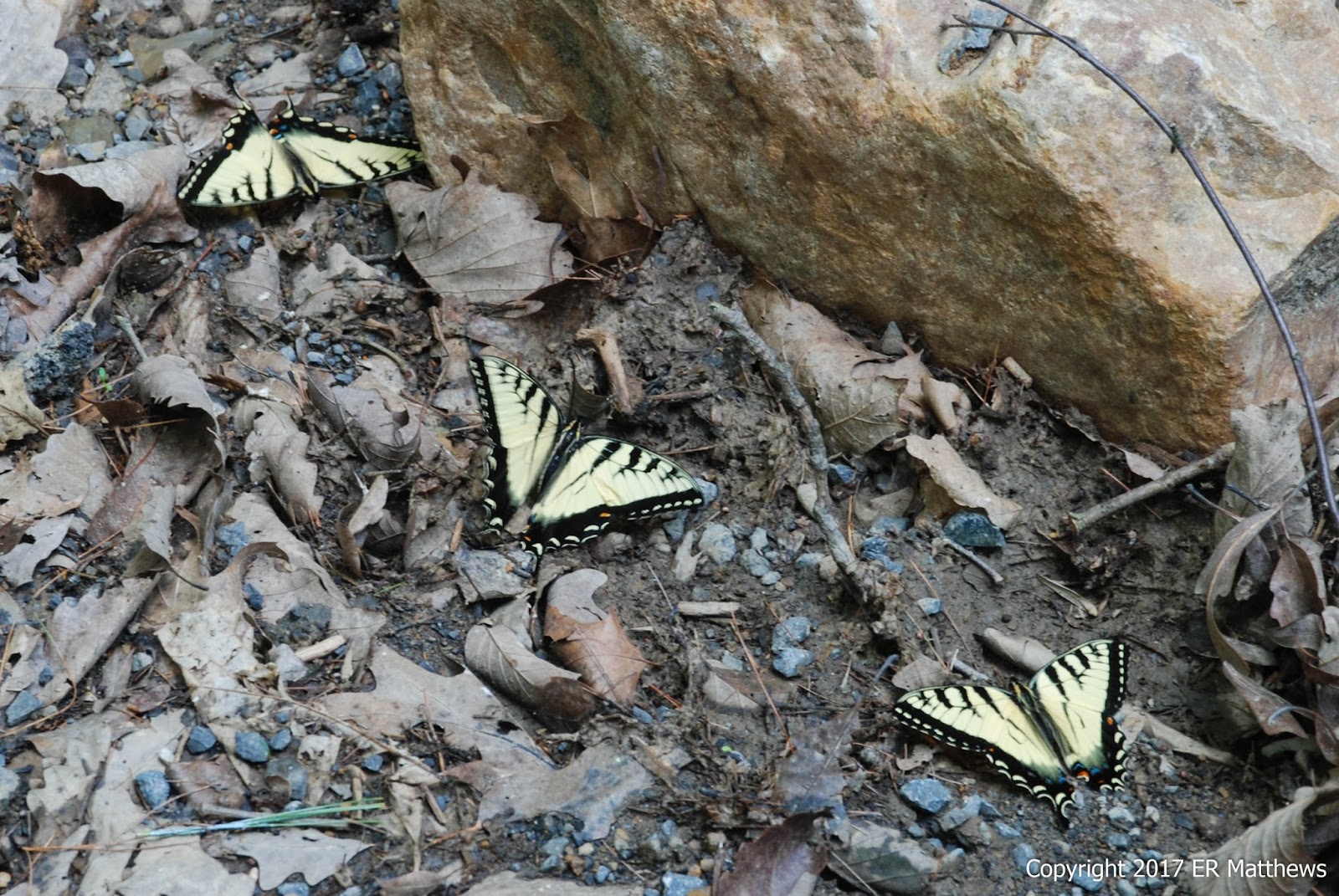
About 10 miles into our hike, the Wilson Cove Trail emptied into Waite's Run Road and we followed the creek downhill a bit less than a mile to the car. All along the road were large patches of Geraniums, but in too much shade to photograph. At one point, we came across a group of Eastern Tiger Swallowtails in the mud and that reminded us that we saw a whirling dervish of four Black Swallowtails about a mile and a half back, flying in a tight circle, resembling a living dust devil.
 |
Eastern Tiger Swallowtail, Papilio glaucus |
Waite's Run is a gorgeous trout stream and although we were tiring of road walk by this point, it was very relaxing walking along listening to the whitewater cascading over the rocks.
 |
| Waite's Run |
 |
| Creek Empties into Waite's Run |
After we packed up, we drove back into Wardensville and had a couple of beers at Lost River Brewing, a tradition after having hiked in this part of GWNF. I enjoyed this hike and it would be a favorite were there a bit less road walking.


It's funny how life works sometimes. I was never certain of the identification of the "greenbrier" above. Today, Ann and I were working an old Sunday New York Times crossword puzzle which had the clue "Devils-bones," a term that neither of us had ever heard. It ended up containing one of the four letters in the entire puzzle that we could not puzzle out without help. We had __ A M and the answer proved to be Y A M.
ReplyDeleteOn googling for an explanation, the search engine returned pictures very similar to the one that I took above, of a plant called Diascorea villosa, with common names wild yam, colic root, rheumatism root, devil's bones, and fourleaf yam.
I stand corrected.