This is our continuing saga of Day 2 at Dolly Sods over the long Fourth of July weekend. In looking for a suitable campsite the night before, I rejected one because there was a game trail running right through the middle of it. I made that mistake once before hiking in on Dobbin Grade, running out of daylight, and stealth camping on the only flat spot I could find in the near dark, a wide spot in a game trail that I couldn't see for the fading light. I paid the price that night, incurring the wrath of dozens of deer pissed off in finding that my tent was blocking their equivalent of an interstate highway. Never again, I vowed.
During the night, a couple of Robins got into a pissing contest about 11:30 and raised holy hell with each other for a couple of minutes. Other than that, no real animal noises until 4am until we were both awakened by a loud series of snorts. Ann, not really having spent many nights in the woods, asked what it was. "It's just a deer," I said and tried to go back to sleep. But the deer was still walking around very near the tent, crunching sticks with its hooves. So, we gave in and both got up to take a pee break. As soon as Ann put her headlight out the tent door, she saw the deer, a large doe, about ten feet away and seemingly unconcerned.
A few minutes later, after lots and lots of slurping and crunching noises, it was clear that the doe was visiting every spot that we had peed since we arrived and trying to lick up some salt. Special. Deer. Noises. In. The. Night. We finally got back to sleep, but by this time, I was getting pretty chilly. We brought small light down throws and sleeping bag liners instead of full-on sleeping bags, given that it was July. I wasn't using the bag liner and as it dropped into the upper 50s, I was getting chilly especially since I have to use the quilt on the diagonal as it isn't long enough for my 6'4" self. Still, I managed to doze off until about 6:45 in the morning.
When I got up, the first thing I saw was the doe that we had seen in the night, still milling about our campsite. She hung around all during breakfast, while we broke camp, and we finally saw the last of her as we stopped at a small creek to filter water on our way south down trail 513 when she trotted off into the woods.
 |
| Our Nocturnal Visitor |
I mentioned in yesterday's post that once we descended south off of Harman Mountain (really, just a hill), the landscape changed and we entered woods with lots of moisture and rhododendron thickets. After breaking camp on Monday and filtering water for the morning hike, we set off further south down trail 513 following Stonecoal Creek. We noticed immediately that areas along the creek were verdant and grassy with hardwood trees, rather than the conifers we saw the day before.
 |
| Different Flora in Creek Bottom |
There were lots of muddy sections of trail to be negotiated and as you might expect, with all the water came a lot of fungi. I thought these scaly mushrooms were pretty neat. They open up into larger fairly standard looking mushrooms. Perhaps they are Shaggy Parasols or Scaly Wood Mushrooms. I really couldn't say.
 |
| Lots of Mushrooms |
Not 20 minutes into our walk, we started seeing Great or Rosebay Rhododendrons, the West Virginia state flower starting to open in small clearings. The further south we walked, first on the east side of the creek, then on the west, and then back on the east, the more and fuller blooms we saw until finally we saw big thickets of white blooms along Breathed Mountain.
 |
| Rhododendron maximum, the WV State Flower |
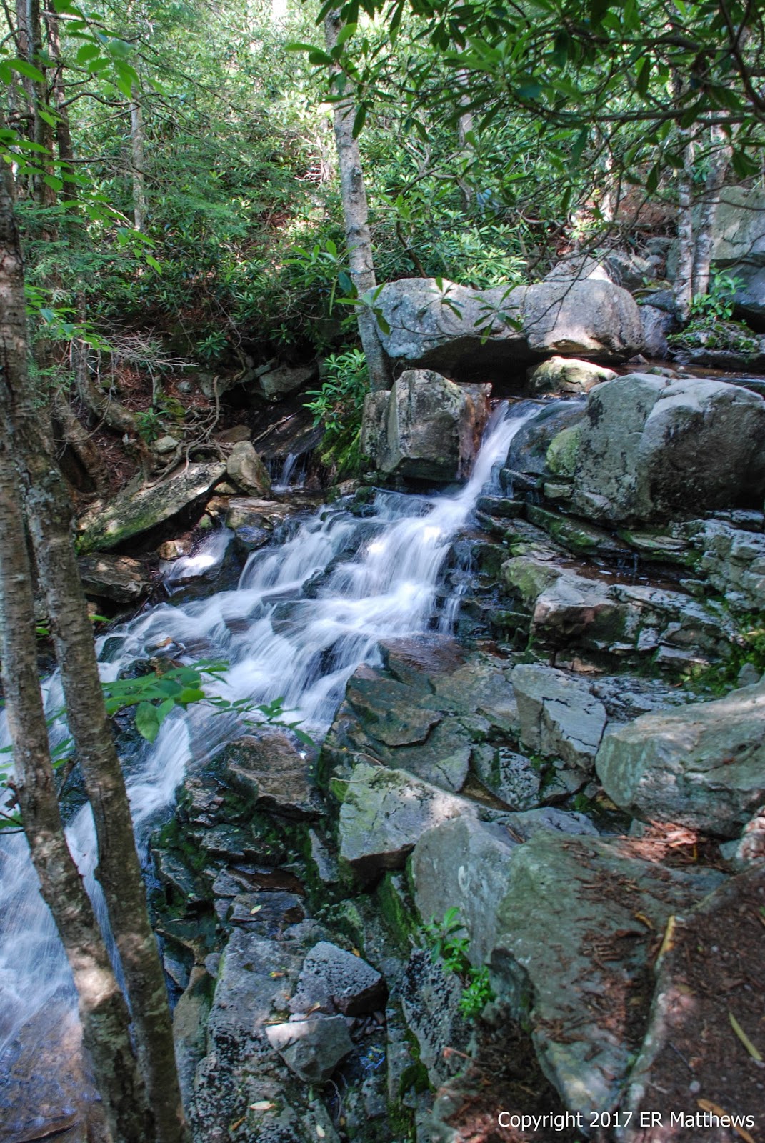
Just after we crossed back to the east bank of Stonecoal Creek for the final time on Big Stonecoal Trail, number 513, we came upon this beautiful little waterfall.
 |
| Falls on Stonecoal Creek |
 |
| Photographing the Falls |
 |
| A Blush R. maximum Bloom |
 |
| A Stunning White R. maximum Bloom |
Soon after the falls, the trail split, 513 continuing to follow the creek south and 554, Rocky Point Trail, splitting left and climbing the side of Breathed Mountain high above the creek. We followed 554 along the mountain for not very far, perhaps a half a mile, when we spied a cairn marking a trail going steeply up the hill to Lion's Head. Down another quarter of a mile, there was another cairn, this one also marked with pink surveyor's tape. I'm not sure it matters how you go up, but just make sure you go to the top.
Hiking Upward says "look closely for an unsigned trail with no blazes, and marked with occasional rock cairns that leads left uphill. This is a rock scramble uphill for the 0.1 miles. Bear right at a flatter area with a nice view of the Lion's Head." Clearly, we went up the mountain before this rock scramble and we had a lot more than just views of the Lion's Head formation.
The important thing to stress is that I know of no other more impressive vistas in the mid-Atlantic area. This has Hawksbill and Big Schloss beat hands down. In other words, do not go to Dolly Sods and pass up the opportunity to climb up on Lion's Head.
We had a steep initial climb, but one well marked with cairns, until the trail leveled out, at which point cairns were no longer necessary to follow the trail through a beautiful stand of pines with excellent camp site after camp site. Literally, you could camp an army up on this plateau of soft pine needles.
 |
| Pines Up on Breathed Mountain |
We followed the trail south about as far as we could go when we spied cairns to our right. We followed the cairns down off the plateau and through the woods, working our way ever closer to the western edge of the hill. At one point, we followed a little side trail out to a rock outcrop that gave us the view of the Lion's Head you see in the photo below. If you stop here, though, you will have missed the entire point. You must get out on top of the Lion's Head and take in the almost 360-degree views. Keep following the trail back north winding through the woods until you emerge onto the rocks.
 |
| Lion's Head |
As you come out of the woods, you'll be on a vast expanse (acres, really) of sandstone with a bit of vegetation here and there. Walk all the way out to the point and soak in the views. While we were out there, we saw an osprey cruising overhead, a bit unexpected but not terribly unusual.
 |
| Coming Up to the Top of Lion's Head |
 |
| Amazing Sandstone Formations |
 |
| Stupendous Views |
 |
| Lots to Explore |
 |
| The Selfie Queen! |
Give yourself a full hour up at the top just to bask in some of the most glorious views you will see on the East Coast. While Annie was climbing about, I was having a look at the flora of the open mountain top. It amazes me how many things are growing up top on seemingly solid rock.
 |
| Mountain Ash, Sorbus americana |
 |
| More Blueberries on Top of the Rocks |
 |
| Red-spotted Purple Butterfly, Limenitis arthemis |
Back down from the top, we continued south around the bottom of Breathed Mountain and curled back around the mountain to the north. 554, Rocky Point Trail, sure lives up to its name with no shortage of pain-in-the-ass rocks.
 |
| Rocksylvania-Style Rocks |
We followed 554 around the mountain and headed back north up the Red Creek valley, ultimately joining 514, the Red Creek Trail, for a short distance before finding a camp site.
 |
| Blooming Stinging Nettle, Urtica dioica |
 |
| Oxalis montana, Mountain Wood Sorrel |
I have been to the so-called Forks before, where the Left Fork of Red Creek merges with Red Creek proper. Not only is it a great place to camp, but it is very popular and boasts great swimming holes. We stopped at the southernmost camp site that we saw, hoping to be as far away from the campers right at the forks. We ended up about 50 yards downstream on a flat in the woods, creek-side.
 |
| Red Creek Just Above the Left Fork |
 |
| The Left Fork Merging into Red Creek |
We were camped at a wide spot in the creek where the main channel shifted away from our camp site and left a large course of rocks between us and the channel. This was not only a great place to go sit and contemplate the world (and watch a doe come down to drink upstream and watch Cedar Waxwings hawk bugs), but it was a great and unexpected place to find wildflowers.
 |
| Beetle and Flies on Ox-eye Daisy |
I am no good at separating the various
Hypericum species (the St. John's Wort family) but the one thing that I do know is that I probably saw seven or eight distinct species at Dolly Sods, the most I have ever seen in a single location. I know that I was surprised to see a shrub form (probably
Hypericum densiflorum) growing all over. I do not ever recall having seen a shrubby St. John's Wort before.
 |
| A Shrubby St. John's Wort, Perhaps Hypericum densiflorum |
 |
| Thyme-Leaved Bluets, Houstonia serpyllifolia |
Along the bank was a plant that was unknown to me that turns out to be called a Northern Bush Honeysuckle. I'm not sure why it is called that or why it has the species name
lonicera, but clearly a
Lonicera it is not. This particular plant was of great interest to a bumblebee that had grossly bulging pollen sacks.
 |
| Diervilla lonicera, Northern Bush Honeysuckle |
As pretty as salsify blooms are, the seed heads are even more spectacular. I cannot tell the species apart by the seed heads, but the blooms are a dead giveaway.
 |
| Tragapogon praetensis, Meadow Salsify |
Finally at long last, I have been able to put a name to a plant that has eluded me for a very long time. I first saw big swaths of it at Blackwater Falls State Park in nearby Davis, WV and it was everywhere at Dolly Sods. No amount of internet searching would turn up a photo that matched what I was seeing, but I finally found a list of plants seen in a scholarly article on the flora of Dolly Sods which listed an unknown-to-me
Rubus, so I checked it out and sure enough: my plant. I am shocked that no matter what permutation of three, leaves, glossy, berry, five, white, petals I used, that I couldn't find an image that matched what I was seeing.
 |
| Bristly Dewberry, Rubus hispidus |
So the funniest thing happened down on the creek around 4:30pm. There were a bunch of us from nearby campsites gathered, filtering water, shooting the breeze, and talking about hiker stuff. The dog in the picture below is named Murphy and he belongs to a couple that were unloading at Bear Rocks at the same time as us the day before, two vehicles down from us. Ann got to chatting with them there and we passed each other a couple of times on the trail.
We met them again at Red Creek and were chatting, when another family came up with a much larger dog. I had my back to the action when I heard one dog giving another what for. I turned to see the little Labradoodle Murphy just yapping away at the much bigger brindled Plott Hound. And then Murphy lay down on the back pack at his feet and hugged it with his forepaws. I couldn't get a picture until the other dog backed off and Murphy lay down guarding the backpack. It turns out that the only food he would eat all weekend was beef jerky and his beef jerky was in the top pocket of the backpack! The whole situation was just too cute for words.
 |
| Murphy, Fearless Beef Jerky Guard |
Back up at our camp site, there was a small basin of fresh water under a hemlock tree. Whenever I would pass it, I would hear a frog jump into the water, so I kept an eye out to see if I could photograph it. Right after dinner, I had the opportunity to snap a picture. I know enough about frogs to know that I didn't know what kind this was with the bright lime green stripe on its upper lip. It turned out to be a Green Frog, a common frog in the east.
 |
| Rana clamitans, Green Frog |
Our day was early and our walk was only 7.5 miles. We got on the trail by 9am and arrived at the camp site by 2 in the afternoon, unlike the previous day when we were after 6pm setting up camp. We messed around the creek for a few hours, made dinner, and then played cards for a while on a rock out in the creek. At this point, it was dusk and we headed for the tent by 8pm, well shy of hiker midnight. The last two things I remember were feeling significantly cooler much quicker in the evening and being serenaded to sleep by the high lisping calls of Cedar Waxwings.
 |
| Playing Cards in Red Creek |


No comments:
Post a Comment