Wednesday, June 26, 2024

Happy Valley Wildflowers

With temperatures predicted to hit an unseasonable number in the low 90s, yesterday was a day to either hit the lakes, the river, or the hills. It proved to be a good time to head back up the North Fork Trail at Tumalo Falls to check on the wildflower bloom at Happy Valley. Last year, this same timing proved to be quite good in terms of bloom. This year, I feel we are 3-4 days behind where we were on the same date last year, but I was not disappointed in the least.

I look forward to this hike each year especially for the concentrated electric mauve bloom of the Jeffrey's Shooting Star, an uncommon member of the lily family that is especially prevalent in this location. Knowing in my heart that it was too early, I tried to get up the trail three weeks ago, but the snow was so high that I abandoned only halfway up the 4-mile climb.

In Happy Valley, Jeffrey's Shooting Star, Primula jeffreyi
Fast forward three weeks and the snow has all but melted and the sawyers have been out clearing deadfall. I crossed about 8 large patches of snow above starting just below the junction of North Fork and Swampy Lakes, most of which were less than 10 yards across. I post-holed twice in the snow softened by the June heat. The big annoyance on this trip was not the snow or the muddy spots, but the mosquitos which have just hatched and are ferocious.

I was wearing long sleeves, long pants, and plenty of bug spray and still I ended up feeling like a pincushion. Wearing long clothing on a warm day in the humid creek corridor is not ideal, but it is part and parcel of making this trek each year. If you are going to see the beautiful flowers, you are obliged to do your part to support the local mosquito population.

The good news is that the snowmelt water is icy and when you need to cool off, you just stand by one of the abundant waterfalls and let the cold air coming off the water waft over you. But you cannot stand for long. Within moments, you will be in a swarm of mosquitos.

My girl Annie would have detested this hike for it had three of her bugaboos: heat, humidity, and bugs. Sorry babe. The flowers were amazing as always. The photos below are in the order I shot them as I walked from my truck parked alongside Tumalo Creek up the North Fork Trail to the intersection of the Metolius-Windigo Trail with Forest Service Roads 370 and 4601. Let's call it a 10-mile round trip.

Happy Valley is an alpine meadow at about 6200 feet of elevation. It appears to be about five open meadow acres bordered on east by the North Fork of Tumalo Creek, on the west by an unnamed small creek, to the south by the junction of the Swampy Lakes Trail, and to the north by the junction of the Met-Win Trail.

The floor of the damp woods as you ascend the trail alongside Tumalo Creek is covered in acres of a member of the lily family. Bright green lily-like leaves are all over, but except for a small patch down at the tiny Tumalo Falls parking lot, none of these plants are displaying their stunning six-petaled white blooms. I call them Clintonia after their Latin name; others call them Queen's Cup or Bead Lilly among other common names. They will be a sight to behold once they get to blooming in earnest.

Queen's Cup or Bead Lily, Clintonia uniflora
I am always happy to run across one of my favorite shrubs, the Twinberry Honeysuckle. It seems to me that it is quite prevalent along the Oregon Coast, but elsewhere in Oregon, it seems limited to damp areas in coniferous forests along the Cascades. In McMinnville, ours grew exuberantly and was the source of much contention in our yard. The Anna's Hummingbirds fought massive battles over feeding rights on our honeysuckle. While I like it in bloom, later in the season, I think the twin glossy black seeds surrounded by bright red bracts are particularly appealing.

Twinberry Honeysuckle, Lonicera involucrata
The sides of the trail in many places are covered in Jacob's Ladder, though it has been very difficult for me to find it in bloom. My trips up this trail have been limited to early spring (the end of June); I'm sure if I went back later in the year that many more plants would be open.

California Jacob's Ladder, Polemonium californicum
Arnicas are beautiful and showy sunflowers, but not terribly common in this area, seeming to prefer higher elevations. I did see a lot of small plants in some of the wetter areas, but this was the only one that I found in bloom.

Heartleaf Arnica, Arnica cordifolia
Double Falls, Full of Water
Sitka Valerian, Valeriana sitchensis
Larkspurs are beautiful plants that need some sun. Each time I go by a certain open area, I know to get off the trail to go see the local ones in bloom. There are so many species of larkspur out west that closely resemble each other that I have no idea which is which.

Larkspurs, Delphinium sp.
Two thirds of the way up the field as you cross the hillside between the middle and north forks of the creek, there's a whole area of large trees, mainly Douglas Fir, that have been blown down. In this relatively sunny location, I found it somehow fitting to find a baby fir growing in a crevice in one of the large blown down firs.

Doug Fir Seedling Growing on Doug Fir Windfall
I Like Where the Creek Cascades Over Many Rock Shelves
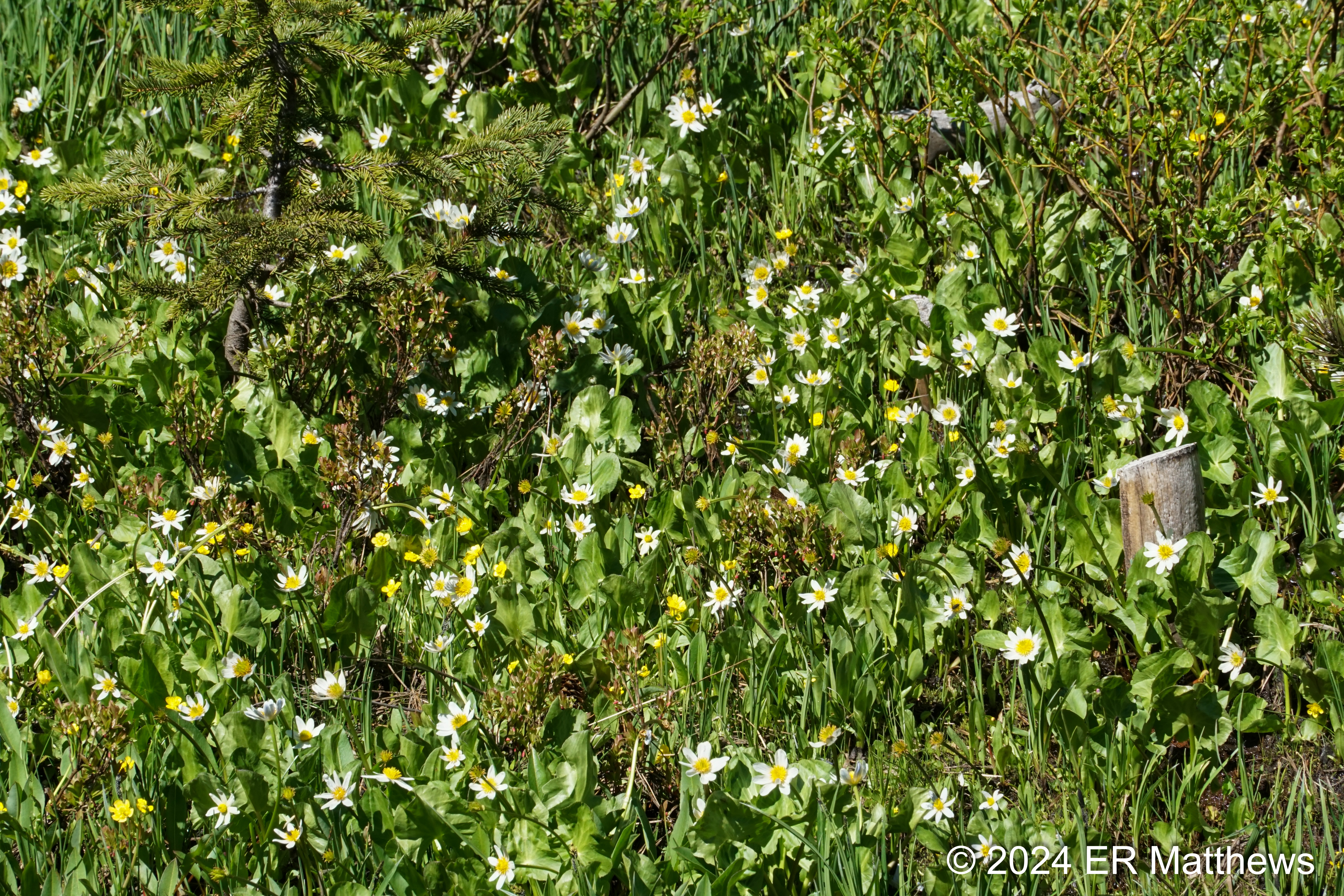
Blooming White Marsh Marigolds are clear signs that a) the snow has just melted b) you're in a boggy area, and c) you've arrived in Happy Valley. Marsh Marigolds along with shooting stars and buttercups are the signature wildflowers of this vernally wet alpine meadow that we call Happy Valley.

White Marsh Marigold, Caltha leptosepala
Alpine False Dandelion, Nothocalais alpestris
Common in the Drier Sections of Happy Valley
Rampant Mountain Buttercups, Ranunculus populago
Scores of White Marsh Marigolds
Jeffrey's Shooting Stars, Creekside
Happy Valley: Imagine a Couple Acres of These Shooting Stars
Mountain Buttercups, Ranunculus populago
Beautiful but Highly Poisonous Emergent Foliage of
White False Hellebore, Veratrum californicum
Cascade Desert Parsley, Lomatium martindalei
While Most Species are Tall, This Alpine Species is Necessarily Low
Tall Meadow-Growing Forget-Me-Nots,
Myosotis scorpioides, Though Common is Not Native to the US
Tiny Western White Anemone, Anemonastrum deltoideum
North Fork at Upper End of Happy Valley
Beautiful Happy Valley, a Roughly 5-Acre Alpine Meadow
Bounded by Two Creeks and Alpine Conifers
An early spring trip as soon as the snow has melted to Happy Valley, despite the ferocious mosquitos, is an especially rewarding trip to see the grass carpeted in blooms of mauve, yellow, and white. I may get up there again later this year or I may not. But assuming that we are in town at the end of June next year, I look forward to seeing it all over again. The sight does not get tiring.

Monday, June 24, 2024

Chicken and Sugar Snap Fried Rice

Fried rice is one of my favorite foods and over the decades, I've made a lot of versions. Just because the dish originated in Asia does not mean that fried rice has to follow an Asian flavor model. I made the following with leftover grilled chicken, sugar snaps, dill, chives, and lemon zest. The fresh herbs I threw in at the last second before plating. Then I zested a lemon on top. It was delicious

Chicken and Sugar Snap Fried Rice
with Dill, Chives, and Lemon Zest
Speaking of grilled chicken, Ann found a marinade that she wanted me to use consisting of onion, parsley, garlic, lemon zest, salt, pepper, and oil, all blended. After making this marinade, I realized that it is almost identical to the way I make jerk paste for chicken. My jerk paste is made from shallots, green onions, a Scotch bonnet pepper, allspice, fresh thyme, and oil. Aside from the flavoring, the idea of blending onions or shallots is pretty much identical.

Grilled Chicken

Roasted Beet and Turnip Salad

It's now getting on to good weather and I'm out walking and hiking as much as I can these days. That's not leaving me a lot of energy for cooking, creating new dishes, or even time to write about them. Here's a departure from all my recent wildflower posts.

After a visit to an early farmers market and coming away with early season ingredients including arugula, beets, and pretty little white Hakurei turnips, I decided to make a salad. 

Roasted Beet and Turnip Salad
with Arugula, Goat Cheese, Croutons, and Spiced Hazelnuts
The very best way I know to treat beets for salads (if you're going to cook them at all) is to roast them. I wrap them in a single layer in an aluminum foil packet and place them in a moderate oven until I can pierce them easily. For these smallish beets at 350F, that was about 45 minutes in the oven. The smaller turnips I treated the same way, but only roasted them for about 20 minutes. I just wanted to soften them and not cook them quite all the way through.

For the salad, I peeled and chopped the beets, quartered the tiny turnips, made some croutons quickly in a skillet on the range, and then toasted whole hazelnuts in olive oil in that same pan before tossing them with a little of my pork spice rub. Everything went into a salad bowl with a bunch of arugula and some crumbled goat cheese. After drizzling the salad with a little extra virgin olive oil, a bit of really good balsamic vinegar, and a sprinkle of salt, I tossed the whole thing and Ann and I set about feasting.

I was really pleased with the addition of the beets to this salad. Their pepperiness complemented the arugula and contrasted pleasantly with the beets.

Saturday, June 22, 2024

Deschutes River Trail: Dillon Falls to Meadow Day Use Area

Between Sunriver and Bend, I have walked all of the Deschutes River Trail from Benham Falls to Dillon Falls and have wanted to go below Dillon Falls this year, but the recent Big Eddy prescribed burns have kept me away until this week. 

The following photos are in the order I shot them, heading downstream to Meadow Day Use Area and then heading back to my truck at Dillon Falls. The walk was about five miles each way, plus another half a mile or so of scrambling to see things off trail.

I last visited Dillon Falls about this same time in 2022. That must have been a cooler year; the chokecherries and the balsamroots were still in bloom then. This year, they are past their prime.

Dillon Falls
The area around the falls is fairly open and sunny. One characteristic group of plants in such open areas is the buckwheats, the Eriogonum genus. Although there are up to 22 species in this part of Central Oregon, the two principal ones, both blooming around Dillon Falls, are the Sulphur-flower Buckwheat and the Rock Wild Buckwheat. I especially like these plants because their flower buds often start red then morph to orange and finally to yellow when fully open.

Sulfur-Flower Buckwheat, Eriogonum umbellatum
Rock Wild Buckwheat, Not Fully Open, Eriogonum sphaerocephalum
This being my first time below Dillon Falls, I wasn't sure what the river would be like. The views from the height of the falls looking downriver below do not suck. Just below the falls is a long, wide, calm section that seems quite peaceful, but even though it doesn't necessarily appear so, the current is moving fairly quickly. Then the river narrows as it heads into a mile-long stretch of rapids, some looking to be about Class III because the turns are tight more than the rapids are rough. Things slow up again just before Lava Island where in high water, the river splits around the island with a class V fall on the main river.

Tranquil Deschutes Below Dillon Falls
I really find the dead or partially dead trunks of manzanitas sculptural and beautiful, in the same way that driftwood, bleached by the water and sun, transforms to something new even in death. Even more interesting at times is finding a manzanita that is partially dead so that the mahogany stems of the living part contrast with the gray, sun-bleached dead parts.

Sculptural Greenleaf Manzanita Trunk, Arctostaphylos patula
A plant of special interest to me is Brown's Peony aka Western Peony, a quite simple but equally stunning version of the large, overbred garden peonies. This is a plant whose highly lobed blue-green foliage is easily overlooked, especially given that it has similar low growing habit and coloration to lupines. Moreover, the blooms which form in mid-May are hard to see because they are nodding, that is, bent over towards the ground such that you actually have to turn the stems upward to see the beautiful blooms.

In any event, these plants have fairly specific environmental habits and are not found everywhere. But they are locally common, meaning that if you find one, your chances of finding others are fairly high. In the area after you descend from Dillon Falls to the river level, I spied tens of plants at fairly widely spaced intervals.

Brown's Peony with Seed Pod, Paeonia brownii
One of my candidates for plant of the month for June is the Diamond Clarkia which really starts blooming in earnest mid-month. I find the four typically fuchsia petals that form a diamond to be really unique and the most fascinating example of the genus that was named after explorer William Clark. I also like the way the plants form: the top is bent over towards the ground like the handle of a cane. This bent top unfurls and straightens as the plant ages and blooms from the bottom of the single spindly stem to the top. Typically in my daily walks about 7-8 miles further downstream, the Clarkias tend to appear as single plants or in small groups. I do not see masses of them together as I did along this section of river, looking to the casual observer like groups of short fireweeds.

Diamond Clarkia, Clarkia rhomboidea
Western Stoneseed, Lithospermum ruderale, Named After Nut-Like Seeds
Columbine Every Three Feet Along the River, Aquilegia formosa
This Year's Crop of Western Serviceberries, Amelanchier alnifolia
Western Swallowtail
Rafts Putting in at Aspen Launch
Ponderosa Pine Male and Female Cones, Pinus ponderosa
Western Blue Flag/Rocky Mountain Iris Riverside, Iris missouriensis
Beetle on a Drymocallis
Cattails on a Slough
Lemmon's Willow, Salix lemmonii, Blooming Riverside
Past the Aspen boat launch, where I met a group of three guides readying a bunch of rafts, rafts that I would encounter on my return trip back up river, the river enters what is known at the Big Eddy, a roughly mile-long stretch of whitewater. It seems to me that no rapids in this stretch would make it to class III except that the river is really twisty and requires some care. The narrowness of the river probably accounts for the class III and III+ ratings.

Nice Bump; I'd Like to Kayak This
Tight and Twisty Whitewater
Buckwheat and Rapids
Can You Spot the Bonus Raven?
A Big S-Curve in the Deschutes
After the Big Eddy rapids and before the Lava Island takeout, the rivers broadens a bit, chills out a bit, and makes a big right hand bend. On the outside of that bend is a rope swing that I saw several testosterone-laden folks using to catapult themselves out into the river. Also at this spot just off the river and bordering the Deschutes River Trail, are the signs of the recent Big Eddy controlled burns.

We had nasty smoke for a few days about two to three weeks back, but the burns have done their job to reduce the fuel load and hopefully we're good in this section for another 5-7 years. The land managers in the Bend area are aggressively burning vulnerable and threatening tracts near town as part of a first in the nation test case on controlled burns or prescribed burns as they like to call them.

On my way back by the Big Eddy Day Use Area, I encountered the rafts I saw putting in at Aspen. On their way down to Lava Island, they had stopped to let their tweenage passengers run off some steam. This seems a bit late in the year for school children; rather, the kids are probably part of one of the many outdoor summer programs that expose the kids to many of the things that we parents love to do.

Evidence of Recent Big Eddy Prescribed Burn
After the Lava Island takeout, where the rafts exit the river to avoid the class V Lava Island Falls, starts the beginning of a long sliver of lava called Lava Island that divides the river into two channels. The main channel containing the falls runs to the east and the high water channel runs to the west. The DRT parallels the high water channel.

Each year after irrigation season is done (October 15), the irrigation district curtails the flow of water at Wickiup Reservoir to start impounding water for the following summer. This decrease effectively cuts off flow to the western high water channel and strands thousands of fish. Many biologists and volunteers capture, census, and relocate these fish to the main river.

The Narrow High Water Channel to the West of Lava Island
Snowbrush, Ceanothus velutinus, on the High Water Channel
About two-thirds of the way north along Lava Island, the trail runs through private property at Seventh Mountain Resort and crosses a dyke along a small impoundment or pond. This pond and the adjacent marshy areas were busy with birds, despite it being high noon.

Male Ring-Necked Duck
Female Wood Duck with One of Eight Ducklings
Tiny Pygmy Nuthatch Ready to Feed Babies
Nuthatch Having Just Fed the Babies the Bug
Pond Behind Seventh Mountain Resort
South of Seventh Mountain, Lots of Spreading Dogbane, Apocynum androsaemifolium
A Stunning Woods' Rose, Rosa woodsii
We are now in the season where the false dandelions (Agoseris) and the salsifies are decorating the trailsides with their puffy seed heads. Though the seed heads can be confusing and I have confused them in the past, they do look a bit different, despite being about the same size (3" in diameter) and about the same height off the ground (1.5'-2'). The Agoseris seed heads look more like overgrown dandelions; the salsify seeds have sturdier stalks and are generally more buff colored.

Key differentiators are the flower buds, the flowers, and the foliage. The Agoseris has small petal-like tabs at the base of the buds; the salsify buds are smooth. The Agoseris bloom looks more like an oversized dandelion; the salsify bloom, while yellow, looks not at all like a dandelion and more like a golden starburst. The Agoseris has a basal rosette of toothed leaves that look like the bills of sawfish. Salsifies have leek-like leaves that come off the central stalk; in fact, the common garden salsify's species is porrifolius, meaning leek-leaved.

Spearleaf Agoseris, Agoseris retrorsa
Yellow Salsify, Tragapogon dubious
Wooly Groundsel, Packera cana, Has Opened This Week
All along the river, I heard and saw hundreds and hundreds of Cedar Waxwings, one of our most common and beautiful song birds, but also one that people do not see all that often. I am most often successful in listening for their high lisping tsee calls and then spotting them. Where you see one, there will likely be a dozen or more because they travel in small flocks. It is not unusual now to see them perched riverside and hawking bugs out of mid-air like the flycatchers, bluebirds, and swallows. Once the fruit has set later in the fall, you'll find them mobbing fruiting trees and shrubs.

Cedar Waxwing, Full Crest on Display
Great Shot of the Red Wing Bar, a Detail not Often Seen
After the end of Lava Island where the two channels come back together, the Meadow Day Use Area sits roughly another two-thirds of a mile along the trail. It was there that I sat on a log for a couple minutes, ate a banana and drank a pint of water before heading back in the direction in which I had come.

End of Lava Island, Two Channels Reuniting
Patch of Invasive Yellow Iris, Iris pseudoacorus
There are patches of invasive and problematic non-native yellow iris all up and down the river. I noticed a big patch at the point where the two channels of the Deschutes reunited at the downstream end of Lava Island. They spread easily (the seeds float downstream and floods wash rhizomes downstream) and while really beautiful, really should be destroyed where possible. Besides being poisonous to livestock, they take over ecosystems and force out native plants that provide forage for animals.

Our Most Common Campion, Douglas' Catchfly, Silene douglasii
I Caught This Red-Winged Blackbird in Full Song
I am not good at identifying penstemons. There are far too many of them, about 30 species in our area, for me to readily tell them all apart. The one in the photo below was sitting outside the Lava Island Rockshelter, a very small cave that once served as a temporary hunting camp for historical peoples. A 1981 excavation found 38 obsidian points and tools such as hide scrapers, the obsidian probably coming from nearby Paulina or perhaps even just across the river at Lava Butte. Obsidian is common all over this part of Oregon. Dating is speculative, but the points are likely old. The tiny shelter was in use for about 10,000 years up to the early 1800s according to one estimate and for about 7,000 years up to 1900 according to another. 

Penstemon Outside Lava Island Rockshelter
I am constantly surprised, as familiar as I am with the plants along this stretch of the Deschutes, to find a plant that I have not seen before. (There are many plants that I have seen before that I cannot name; the yellow ray flowers come to mind.) This one, hiding in the shade of a large basalt boulder is clearly a campion, but which, I had to look up. Our usual one is Douglas' shown in an earlier photo; this is Menzies'.

Menzies' Campion, Silene menziesii
Tiny Juniper Hairstreak Butterfly on a Yarrow, Achillea millefolium
In this 5-mile stretch of river, I saw 4-5 active osprey nests and several ospreys plying the air above the river offering their noisy calls to all who would hear them. The nest below was the most picturesque being built in the dead top of a still living Ponderosa Pine. This concentration of ospreys likely means that there are plenty of fish in the river to support them. And in fact, I saw fly fisherman landing both rainbows and browns on my stroll.

Osprey at a Nest
A final thought: the Deschutes River Trail is not a single trail, but a collection of trails that wander along the river. In many places, there are options to go closer to the river and farther away from the river to visit or avoid certain places. When I do an out and back like this, I like to explore the different options on the way out and on the way back.

Just at the end of the canyon that contains Dillon Falls, you can take a fairly mild trail through the woods down to the river level or you can take a very steep trail immediately down to river level. On the way out, I didn't really pick up on the steep trail down; I assumed it was just a path to an overlook. Later, I saw where this trail rejoined the trail I was on and made a mental note to take that trail on the way back. I'm glad I did, for it was on this trail that I found the most glorious patch of lupines that I have seen this year. Sadly, with so many lupines in this area, I don't have the skill to tell which kind this patch contains, but I am happy to have seen them.

Quite the Lupine Display
In completing this section of the DRT, I have walked from the east bank of the river near Benham Falls, crossing the river on the old railroad bridge, all the way to Meadow Camp. That leaves only the section from Meadow Camp into the southern outskirts of Bend still to walk, the section that goes behind Good Dog, Loge, Eagle Crest, and Mount Bachelor Village. I have walked a good bit of that part of the river on the east bank.

On the west bank, I believe most of that is private property, so at Good Dog, I think I'm going to have to walk a section of the Haul Trail into Mount Bachelor Village before descending back down to river level. I hope to walk all the way from Sunriver to Bend next week.

Happy Valley Wildflowers

With temperatures predicted to hit an unseasonable number in the low 90s, yesterday was a day to either hit the lakes, the river, or the hil...