Our plan for today was to leave Vegas and head west to California to spend time in Death Valley before heading back across the border to Beatty NV where we would spend the night in preparation for day two in the national park. After leaving Vegas, we climbed up and crossed through the Spring Mountains before making a long arrow-straight northwest beeline for the town of Pahrump. From a few miles west of Vegas, the flat roadsides are covered in a sparse mix of Creosote Bushes and short Joshua Trees, a form of yucca and not really a tree.
The last time I drove this stretch of highway, it was dual lane and not a divided four lane if memory serves me, and the wide open spaces gave no frame of reference for my speed. You can see for miles in all directions and I could see headlights behind me catching up for many minutes. As the headlights neared me quickly, it made me wonder how fast the approaching car was going and I looked at my own speedometer. Without a frame of reference and without cruise control, I was tearing through the desert at over 100 miles per hour. I was shocked, but not as shocked when a first generation bright red Acura NSX blew by me like I was parked.
In any case, Death Valley is in the middle of nowhere with minimal services: few places to eat and fill up the gas tank. We stopped for gas and groceries in Pahrump, a small town that has expanded vastly in the more than 25 years since I last visited it. We got bagels, salame, and hard cheese, items which can handle time in the car and the heat and still be decent to eat without refrigeration. The grocery store brand bagels that we bought, we ended up calling cakels, for their soft cake-like texture. Our local WinCo has passable (not great, but edible) bagels; these only had their shape in common with real bagels.
 |
| Landscape Headed to Death Valley |
 |
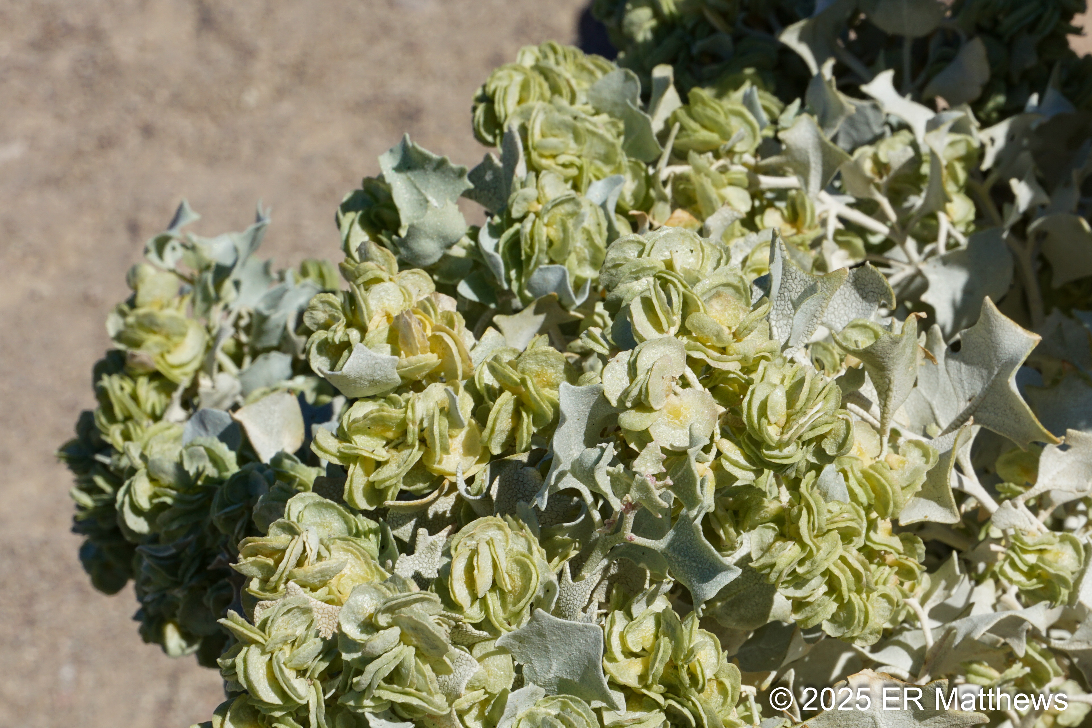
| Desert Holly in Bloom, Atriplex hymenelytra |
 |
| No Idea What Plant Makes the Hillsides Rusty Red |
Once out of Pahrump, we turned west and headed past Ash Meadows National Wildlife Refuge aiming for Death Valley Junction. Continuing on past the quirky and eclectic Amargosa Opera House, we motored on west into California. Just at the boundary of Death Valley National Park, we spied the white rear ends of a group of Bighorns on a hillside off in the distance, but we did not stop. They were a quarter mile in the distance and well out of camera range, even with my huge lens.
 |
| Annie Photographing a Tiny Beavertail Opuntia |
The largest park in the Lower 48, Death Valley National Park is vast and remote (not as vast or as remote as say Katmai in Alaska) that requires a commitment to a lot of driving. While the park is larger, Death Valley itself is a 156-mile-long basin sandwiched between two mountain ranges: the Amargosa Range on the east and the Panamint Range on the west. DVNP is also a place of extremes. Not only is it the hottest place in the country (hence our winter trip), it also has extreme elevation differences. Telescope Peak (11,049 feet), visible just about everywhere in the park, is only 15 miles from the lowest point in the U.S., Badwater Basin at 282 feet below sea level.
Because of its vastness and remoteness, there is precious little signal in the park, so navigation is via old school paper map (or in my case, a PDF of the paper map with a paper map for backup). Signage is OK in places and absent in others. Also we found that a series of devastating floods in 2015, 2022, and 2023 damaged a lot of roads making them impassable. Visitors should be prepared for navigation and self-sufficiency and should definitely check in with the rangers at Furnace Creek Visitors Center about current road conditions and closures.
The first thing I wanted to show Ann, who had never been to Death Valley, was the amazing views at Zabriskie Point. An ideal spot from which to watch the sunset, this high point offers an expansive view of the badlands below, the salt flats of the valley beyond, and the Panamint Mountains to the west. This most photographed area of the park has scenery that rivals that of Badlands National Park in South Dakota.
 |
| Manly Beacon (c) and Red Cathedral (r) |
 |
| Telescope Peak Beyond the Badlands |
From Zabriskie Point, although we wanted to visit Badwater Basin, we continued past the turn-off to stop in at the Furnace Creek Visitors Center. There I wanted to get my park pass, but more importantly, to get a paper copy of the PDF map that I had already downloaded onto my phone, in case of issues with my phone. With the temperature pushing into the upper 80s, we were fortunate to find parking under an awning opposite a line of invasive tamarisks, planted by man and some of the very few trees in the park. After trading obligatory and good-natured barbs with our ranger (who went to rival school VaTech while I went to UVa), Ann and I backtracked south towards Badwater Basin.
Badwater Basin is about 18 miles south of the ranger station (in terms of the vastness of the park, 18 miles is close) and is home to the lowest point in the U.S. at -282 feet. Now in February, there is still a bit of water in the basin and the salt flats are still a bit moist. It will dry out as summer approaches. Ann tasted the salt and declared it “super-salty.”
 |
| White Sign Shows Sea Level |
 |
| My Phone is Too Low by 22 Feet |
 |
| Salt Flats in Front of Telescope Peak |
 |
| Still Some Salty Water in Badwater Basin |
Badwater Basin was highly crowded with obnoxious Instagrammers taking videos of themselves and with tourists walking their dogs on the salt despite signs clearly stating "No dogs." I knew that we could experience more of the salt and much more solitude at Devil's Golf Course a few miles to our north. I had already seen only a handful of cars in the parking lot as we passed it, so we got away from the hordes as fast as we could.
Devil's Golf Course is a place where you can drive out into the center of the basin and walk among the salt formations formed by the wind and the rain. You might expect the salt to be soft and sandy as it is at Badwater, but it is the opposite. The salt formations are hard, spiky, and will scrape you if you are careless. From the paved road, Devil's Golf Course looks flat, but walking in it, it is anything but flat with chunks of salt, some knee high.
 |
| Devil's Golf Course |
 |
| Salt: Rock Hard and Deadly Spiky |
Continuing back north, I wanted Ann to experience Artist’s Drive, a loop that meanders through the rock formations and badlands and known for its display of multi-colored rock and earth. The loop is one-way from south to north and just a short way into the loop is a large parking area that people use to to look at the beautiful tones of the earth.
Here, while I was photographing the colored hills that most tourists stop to see, Ann took off to climb a nearby hill. I joined her and we continued to follow the ridgeline west (odd in a north to south oriented valley) until we could go no further. The views of the valley with its salt flats and of the Panamints to the west were amazing. It is these off-the-beaten-track experiences that Ann and I seek, leaving the ordinary tourists far below.
 |
| The Hillsides Have a Lot of Colors and Color Variation |
 |
| Desert Holly Seed Pods, Atriplex hymenelytra |
 |
| Ann, Off on an Explore |
 |
Looking South Down Death Valley
The White is Salt, not Water or Sand |
 |
| Ann Headed for the End of the World |
 |
| Telescope Peak in Background |
We continued driving Artist's Loop and took the brief detour to the Artist's Palette overlook, the principal thing that most people come to see. Although the bright afternoon light was not ideal, we do not often get to choose our time to visit things. Still, the hills are beautiful, especially the green rock and soils. The so-called palette is an array of rock in pink, red, orange, yellow, green, and blue. Each shade indicates a different mineral composition.
 |
| Take in the Tones and Textures |
 |
| Artist's Palette from Afar |
Our final stop before heading north in the park was the Golden Canyon trailhead. Ann was too hot on this trail in the late afternoon, so she went back to the car while I hiked to the massive red stone formation called Red Cathedral and the large yellow stone monolith called Manly Beacon. Unfortunately, my destination took longer than expected to reach and Ann sat in the car worrying about whether or not I had fallen and hurt myself. Knowing I was running late, I jogged back to the car, where the terrain would let me. I don't recommend jogging in Death Valley. I chugged a pint of water back at the car.
 |
Opening to Golden Canyon
These Canyons are Fissures Eroded by Water |
 |
| Golden Manly Beacon |
 |
| Red Cathedral |
 |
| Zabriskie Point is Hidden by Manly Beacon |
I was tired after my jog and I could see that Ann was sagging, so we started heading for our motel in nearby Beatty NV, about 45 miles to the north and slightly east. Such are the distances out west, that 45 miles is "nearby." We booked a room for two nights at the Death Valley Inn in Beatty because the only rooms left in the park proper were about $500 per night. We did not know that our visit coincided with the Dark Sky Festival which brought scads of stargazers to the park. All we knew is that there were no affordable rooms left.
We headed north from Furnace Creek and took the Beatty Cutoff which runs up through Daylight Pass between the Funeral and Grapevine Mountains, a nicely scenic drive past Corkscrew Peak. Once through the pass, we crossed back into Nevada and pushed on for Beatty another ten or so miles to the east.
Ann had apparently done some research on Beatty before we left Oregon and understood that wild burros were part and parcel of a visit. I did not have a clue until we crossed back into Nevada and neared the Rhyolite ghost town where suddenly, several burros crowded the roadside. Nearly standing in the road, they presented a traffic hazard to those cresting the hill for a sudden and high-speed close encounter.
 |
| This Girl is Big Pregnant |
 |
| Those Fuzzy Ears! |
Suddenly, we dropped down into Beatty which appears to mostly be a hardscrabble collection of modest houses with a small collection of commercial buildings centered on the intersection of U.S. 95 and NV 374. In this tiny town of perhaps 800 people, it was no challenge to find our motel, even without the benefit of GPS.
As we entered the motel to check in, I noted the burro images painted everywhere, the piles of burro manure under the planted palm trees out front, and the burro figurines in the motel lobby. I was suddenly coming to understand that burros are important here. Although they are bordering on a nuisance in town and present traffic hazards, they are a federally protected species. A local told us that they run to about a thousand strong versus only about 800 people.
At the motel, we heard burros braying nearby. That night, we almost hit a black one coming back from dinner in the dark; I never saw it in the shadows. Ann did. We would later see this same black burro use his snout to open a dumpster and rummage for snacks. They are everywhere.
After a hard day of play in the hot sun in arid Death Valley, we were ready for a beer. Options are limited and rather than going to the sole convenience store in town and grabbing a six pack, we ended up at the Happy Burro Chili & Beer a few hundred yards from the motel. A couple of well lubricated locals showed us the entry to the tiny establishment that puts the D in dive bar. We grabbed the two remaining of four seats at the bar, There were a couple of tables behind us with room for another 6 or 8 people. We had many choices of beer on tap: PBR, Bud, or Battle Born Lager from Reno. I chose Battle Born, a Bud clone only slightly better tasting. Fortunately, the bartender found a couple of Coronas for Ann in the walk-in.
We had a good chat with the 3-4 locals in the bar as well as the bartender. Ann and I were the only non-locals. Everyone was friendly and welcoming of us visitors to their town. After a couple of beers, we got two bowls of chili, the only food on offer, dished from a soup warmer behind the bar and topped with grated cheese and diced onions. The chili was surprisingly good and exactly what you would want it to be.
 |
| Ashtrays and Dogs on the Bar |
 |
| Battle Born Lager and Chili |
Well after dark, we headed back the couple of blocks to the motel. I noted in the parking lot many motorcycles and a few off-road vehicles too. I do not know if the off-roaders were headed to Death Valley National Park where off-roading is forbidden (but still done quite a lot in the vast park) or if they were driving one of the many local off-road trails. As I was going to sleep, I heard still more loud vehicles and bikes pull in.


No comments:
Post a Comment