Saturday morning, day two of our Death Valley adventure started with coffee and breakfast in the lobby of our motel. And by that I mean of couple of cups of Folger's finest and a couple of pre-packaged Jimmy Dean breakfast sandwiches that I put in the microwave. After the quick breakfast and as we walked back to the room, we noticed a couple of ornamental pears in full bloom (in February!), a lot of Great-tailed Grackles making tons of noise, and a friendly enough long haired yellow cat which seemed to guard our door.
Great-tailed Grackles are large noisy birds of the Southwest that I know well from my student days at Texas A&M where they roosted in the Live Oaks along the sidewalks at night. Every morning, the grounds crew at the university would take high pressure hoses to the sidewalks, trying to wash away the massive amounts of grackle poop from the walkways, an unpleasant task that to this day evokes a nasty smell memory. It is coming up on mating season for these birds and Ann and I chuckled at a group of three males on the terra cotta motel roof posing in a huddle with their bills pointed skyward, a classic grackle display.
 |
| Ornamental Pear in Bloom in February |
 |
| Male Great-tailed Grackle |
 |
| Female Great-tailed Grackle |
 |
| Guardian of our Room |
Our agenda today was to see parts of the park that I have not seen before. Yesterday, I showed Ann the sites with which I am familiar in the Furnace Creek area. Today, we would drive from Beatty NV to the far western side of the park and back, through Stovepipe Wells, Emigrant, and Panamint Springs, taking in the sights along the way.
We left early to get ahead of the sun, meeting more burros on the way out of town. When I stopped so that Ann could take pictures out the passenger window, three of them bum-rushed the car, intent on securing snacks and a shoving the car a bit more aggressively than I was comfortable with. With no intention of feeding them and adding to the burro problems, I quickly rolled up the windows and slowly pulled out into the road with the three burros leaning on the car. I did not want them to snap off the sideview mirror, so I drove steadily but slowly forward and away.
On the way from the park to Beatty yesterday, we marveled at the afternoon sun striking on Corkscrew Peak and noted the cars parked alongside the road, presumably from hikers set out to scale the mountain. The top of the peak, if you use your imagination, certainly appears twisted, but I might not stretch from that to calling it a corkscrew. This morning, we stopped on the roadside to check out the peak in the morning light and to have a look at the plants growing on the side of the road.
 |
| Corkscrew Peak |
 |
| Red and White Roadside Boulder Detail |
 |
| Pygmy Cedar, Peucephyllum schottii
Not a Conifer at All |
 |
| Desert Sculpture: A Very Old Creosote Bush, Larrea tridentata |
 |
| Red Cinder Hillside with Desert Holly, Atriplex hymenelytra |
We continued on for a couple miles until we could see the flat part of Death Valley, the basin bottom. From our hillside vantage point, it was obvious in the morning light that the ground was not a salt flat but clearly demarcated dunes. It was these dunes that was to be our first long stop of the morning.
 |
| Mesquite Flat Sand Dunes with Stovepipe Wells Hamlet at Far Right |
Our first sight to see was Mesquite Flat Sand Dunes just before the Stovepipe Wells Ranger Station. We chose it first because the light for photography is best early, plus the temperature out on the dunes becomes inhospitable as the day wears on. Accordingly, we arrived at 8am and wandered out into the dunes for 45 minutes or so. The sand was still cold. When I went out to breakfast wearing my shorts, it was a chilly 40 degrees or so. The Mojave, just like the desert here in Central Oregon, gets hot in the day and cold at night.
 |
| Honey Mesquite, Neltuma glandulosa, Just Leafing Out |
 |
| Just Starting Spring Bloom, Creosote Bush, Larrea tridentata |
 |
| Water Has Pooled in Low Places, Leaving Cracked Mud |
From Mesquite Flat, we set out west for the far side of the park and the Father Crowley overlook where we would eat lunch and turn back around. To get through the park, we first drove through Stovepipe Wells, a cluster of perhaps ten buildings including the ranger station, a hotel, a cafe, and a general store/gas station. Continuing on through the vast and flat basin, we passed through
Emigrant. I found it funny that a wide spot in the road with one or two structures and a tiny campground has a place name.
From here we started climbing the mountains and passed through Towne Pass at 5000 feet. Coming down out of the mountains and headed west in the direction of Panamint Springs, we came to a spot where we saw about a 4-mile long straight stretch of highway running arrow-straight across the valley floor. We stopped to take pictures on either end.
 |
| Shooting to the West; the Tan Ground is Sand Flat |
 |
| I am Shooting Back East |
 |
| The Who: "I Can See For Miles and Miles and Miles" |
Just west of Panamint Springs, also a clustered handful of buildings, a dirt road heads south to the water source for the town and a rarity for Death Valley, a waterfall called Darwin Falls. Unfortunately, the 2023 flash floods washed out the dirt road, forcing visitors to hike in from the paved highway. That extra distance made the hike too long for our schedule.
We continued climbing the mountains to Father Crowley Point and Rainbow Canyon. Up to 1000 feet deep, the canyon is named for multicolored stripes on its sides and was formerly known as a place where military jets would fly through on training runs. We drove beyond the overlook to look straight down from the top of canyon then we drove down a washboard dirt road to look over the valley.
 |
| Desert Gold, Geraea canescens, at Panamint Springs |
 |
| Also Known as Hairy Desert Sunflower |
 |
| Looking East Over Death Valley |
 |
| Some of the Rainbow in Rainbow Canyon |
 |
| Rainbow Canyon |
 |
| Extraordinary Clouds |
 |
| Just Wow! |
 |
| Road Climbing to Father Crowley Point |
 |
| More of the Road Climbing the Mountain |
 |
| Odd Vein of White in Otherwise Red Rock |
After having lunch at the top of the mountain, we retraced our trip all the way back to Stovepipe Wells where we turned right on a dirt road and climbed two miles up a broad alluvial fan to the Mosaic Canyon trailhead. The two-mile-climb brought us to about 1000 feet above Stovepipe Wells Village and to the most impressive walk in all of Death Valley.
The walk up Mosaic Canyon is all about geology and if you are not fascinated by geology, what are you doing in Death Valley? Besides geology, Mosaic Canyon has two other things going for it. It is shaded in large part for most of the day, a rarity in this sun-blasted area, and all of the best parts are in the first half a mile, meaning that you can see the canyon without committing to a lot of time out of your schedule.
If you had any doubts that the canyons in Death Valley were carved over time by water flows and floods, the smooth water-polished marble walls of this canyon will clear up those doubts. This area was at one point at the bottom of the Pacific Ocean. The common limestone of the region, dolomite, was buried in ocean sediment over eons and as the pressure built up, the limestone morphed to marble.
Marine rockslides dumped a lot of rubble on top of the limestone where finer sediment and lots more pressure converted the rubble to rock. Uplift and subsequent erosion of the canyon have exposed areas of that cemented rock called breccia or mosaic breccia. Breccia, meaning fragments in Italian, comes from the angular bits of rubble that appear similar to bits of tile in a mosaic. Similar rock made from rounded river or beach stones is called conglomerate. The technical name aside, the distorted rock formations exposed in this canyon boggle the mind as to how it was sculpted by nature. Our visit was so worth the brief detour.
 |
| Veined Marble, Smooth and Silky to the Touch |
 |
| Large Vein of Upthrust Marble |
 |
| Some of the Breccia Formation |
 |
| Intricately Veined Marble |
 |
| Same Marble After I Wet it to Highlight the Veining |
 |
| Annie in a Niche in the Breccia Carved by Flowing Water |
 |
| Center of Photo: Annie Climbing on Very Slick Marble |
 |
| Zebra-Tailed Lizard |
 |
| Desert Rock Nettle, Eucnide urens |
 |
| Cooling Off on a Cold Marble Shelf |
 |
| Another of the Many Zebra-Tails |
After our midafternoon walk up Mosaic Canyon, we were headed back to the junction where CA190 turns right and heads south toward Furnace Creek. Just before the junction, I pulled over to see what is called Devil's Cornfield, an area of desert that is full of Arrowweed plants that some say resemble shocks of corn gathered and left to dry in a cornfield. For my part, I have never seen arrowweed before and just wanted to have a look at it to satisfy my curiosity. It only grows in areas near water, so the water table must be just below the surface here. It gets its common name from its stems which were used as arrow shafts.
 |
| Arrowweed Shrubs at Devil's Cornfield |
 |
| Interesting Foliage of Arrowweed, Pluchea sericea |
Continuing on to the junction, we would decide whether to head north, south, or continue east to Beatty. We ruled out the hour-long drive to Ubehebe Crater up north because we were low on both energy and gas. Having missed out on Darwin Falls because of washed out roads and very curious about what riparian zones look like in the middle of a desert, we decided to head south towards Furnace Creek to see the Salt Creek Interpretive Trail. We saw no signage where the road should have been, but we did see barricades: this road too had been washed out.
So, not for the first time during the day, we thought about another plan B. We took the Beatty Cutoff to get us headed back to Nevada with the idea about perhaps stopping to see the remains of the Keane Wonder Mine. The attraction of this old gold mine is the partially restored aerial tram line that moved up to 70 tons of gold ore per day at the height of the mining operation in the early 1900s. When we got to the turn-off, the dirt road appeared pretty rutted. In my Tacoma, this would have been a no-brainer, but driving a rental car made me opt for staying on the pavement. We had had enough bumpy dirt track for one day at both Father Crowley Point and Mosaic Canyon.
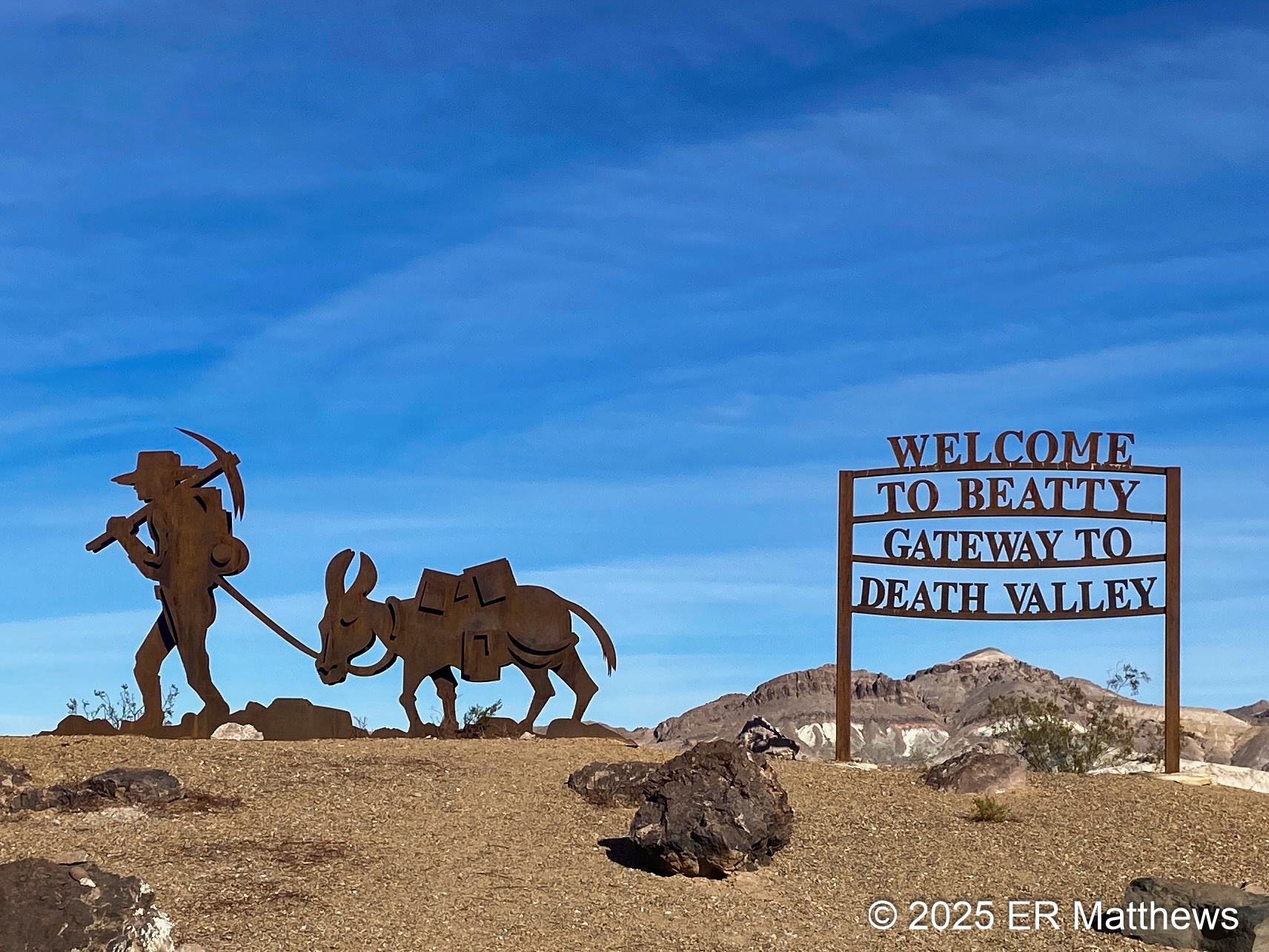
So we kept pushing on past Corkscrew Peak and through the mountains at Daylight Pass to Beatty with a mission to get both gas and beer which we accomplished at the convenience store just down the street from our motel. We shot a few pictures of Beatty as we passed through the little town.
 |
New Steampunk Sculptures on Unopened Exchange Club Casino
Building Relocated from Nearby Rhyolite, Now a Ghost Town |
 |
| A Really Large Joshua Tree, Yucca brevifolia |
Although we enjoyed our experience last evening at the Happy Burro, we opted to stay in this evening and eat from our supply of lunch food that we bought in Pahrump. During the evening, we discussed what to do tomorrow before seeing the Cirque du Soleil show at the Bellagio at 7:00. Ann had been wanting to see a show at The Sphere. I agreed and she bought tickets for a show in the afternoon before our condo would be available for check-in at 4pm. On the way back, I wanted to show Ann the Harmony Borax Works, 20 Mule Team Road, and Dante's View.
And so we went to bed with the plan to see a few remaining points of interest in Death Valley, then scoot to Vegas in time for the show at The Sphere, check-in to our hotel, and then walk down to The Bellagio for drinks, see the show, and then find dinner after. Tune in to the next post to see how these plans worked out.


No comments:
Post a Comment