To beat the terrible end of July heat in Central Oregon, we decided to spend a couple days at the Oregon Coast where the daily highs were forecast to be at least 30 degrees less than at home in Bend. I planned to take the slower but more scenic route through the Cascades to the coast. This post covers the trip from Bend through Sisters to Eugene.
Ever since I first read about the wildly scenic McKenzie Highway, OR 242, that runs west-south-west from Sisters to the junction at Belknap Springs with OR 126 heading south out of Santiam Pass, I knew that I wanted to drive it. The highway is only open and snow-free for a very few weeks out of the year, from late June through the end of October. Our trip from Bend to Yachats was the perfect opportunity to explore this phenomenally scenic byway.
OR 242 leaves Sisters at its northwest corner just beyond downtown and the Sisters Ranger Station if you are coming from Bend. At first, once beyond the two schools in Sisters, the road rolls and climbs slowly through a beautiful forest of widely-spaced Ponderosa Pines undergrown with Snowbrush. On our drive up to the pass along this bucolic route, we saw dozens of cyclists, coming downhill from the pass into Sisters, enjoying the downhill and the shade of the tall pines.
The further you ascend the road, once a wagon trail over the Cascades, the more it twists and turns, with the landscape becoming progressively harsher. The tall Ponderosas give way to a sparse scattering of Lodgepole pines until about ten miles in, all the tree cover gives way to vast acres of inhospitable lava and expansive views of Mount Washington. Back in Bend, Mt. Washington appears to be crowned by a steeple, but up close like this, it becomes clear that the steeple is really a large spire of hard stone in what is obviously a deeply eroded volcano.
 |
| Mount Washington from Southeast |
 |
| Rockscape Around Which the Road Twists |
The next thing you know, you have climbed into the saddle of McKenzie Pass just at about 5300 feet with parking to the left and the Dee Wright Observatory to the right. The Pacific Crest Trail passes through the saddle a couple of tenths of a mile beyond the observatory and the pass is ringed on all sides with vast volcanic mountains and buttes.
 |
| McKenzie Pass: Equidistant Between North Sister and Mt. Washington |
 |
| Dee Wright Observatory |
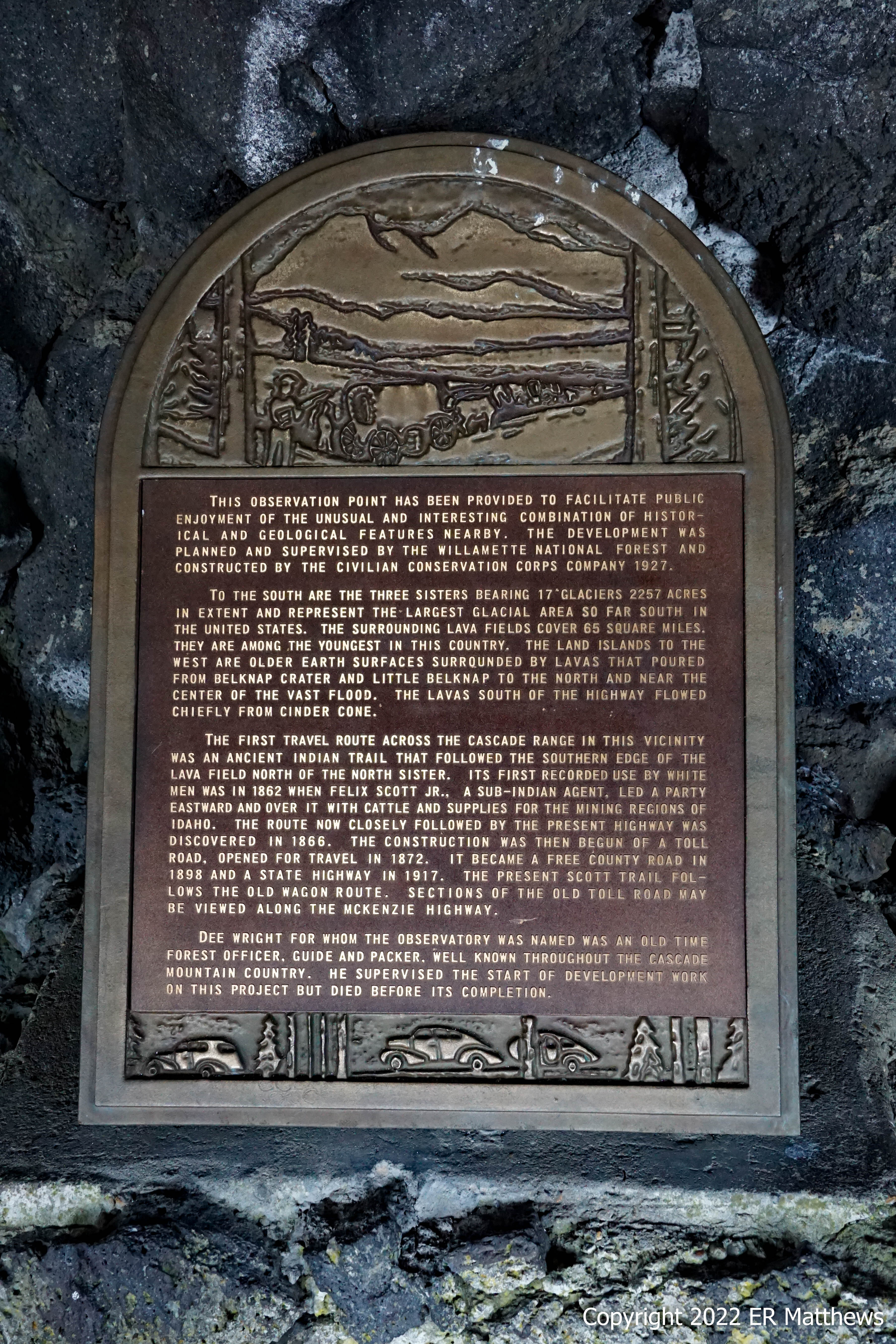
The Dee Wright Observatory is a Depression-era Civilian Conservation Corps open shelter just above the pass. It is a circular tower built of lava with an enclosed first floor and an open second floor. The second floor offers 360 degrees of view of the surrounding mountains and hosts a circular brass peak finder that locates each of the peaks in view.
The lower floor has window openings framing views of the major peaks, with small tube sights through the walls focusing your gaze on each peak. It is a wonderful learning tool for those of us who want to be able to name the geographic features around us. Unfortunately for us, a lot of haze from the huge wildfire at Yosemite moved in the night before and limited our views. On a clear day, it is possible to see Mt. Hood 77 miles way up north, but on our visit, nearby (29 miles) Mt. Jefferson was looking very hazy.
 |
| Artsy Shot: Washington left and Jefferson right |
 |
| Peak Finder in Front of the Sisters, North Sister Most Prominent |
 |
| Peak Finder Detail |
 |
| Annie and the Sisters |
 |
| Informational Plaque Inside Shelter |
 |
| Mt. Jefferson Over Ann's Right Shoulder |
 |
| Inhospitable Terrain with Black Butte Right |
Leaving the parking lot and headed west downhill for the first time in 15 miles, all of a sudden the landscape began to change. Whereas the east side is all Ponderosa Pine lower down with scrawny Lodgepole Pines higher up, the east side reverts very quickly to Douglas Fir, the most common tree in Oregon. A minute or two beyond the Pacific Crest Trail, we spied a lot of Beargrass growing on the roadside, a plant I haven't seen in many years.
 |
| Beargrass, Xerophyllum tenax |
From the pass, it is almost 5000 feet of descent to Eugene and the lower we got, the more we found ourselves in typical west side wet Douglas Fir forest. Only after twisting lower and lower would we see Big-Leaf Maples and then finally open Oregon White Oak savannahs so typical of the Willamette Valley.
Once we turned left onto 126 for the straightish shot west into Eugene, we would follow the delightfully scenic McKenzie river all the way to its confluence with the Willamette. By this time, it was time to deal with our hunger, especially since we ate no breakfast. Finding lunch in Eugene was the next item on our agenda.
Traveling through the Cascades, if you want to search for something on the internet or even use your phone to navigate, you quickly learn that this is a non-starter. Signal is nigh on non-existent. It was only within a few miles of Eugene that we got enough signal for Ann to search for a place for a quick lunch and a beer. Not knowing the beer scene in Eugene at all, Ann made a totally random choice of Gratitude Brewing in downtown near the U of O.
We parked around 12:30 immediately in front of the small place and pulled up a couple of seats at the empty bar. Quickly, we found ourselves sipping two really excellent beers and I don't say excellent lightly, coming from one of the country's great beer towns. If this place were in Bend, it would probably be our favorite haunt. Furthermore, our lunch sandwiches were better than just about any pub food in Bend, not bad for choosing a brewery at random.
Needing to get on the road, we finished our lunch and our beers and got a couple of crowlers to-go, the plan already forming in my mind to have happy hour overlooking the ocean with some salami and cheese that we would pick up en route out 126 to the coast.


No comments:
Post a Comment